112earthquakes
in August 2026
The strongest had a magnitude of 1.6; almost all were beneath the crater in the uppermost kilometer, and 49 of them were below magnitude 0. In the twelve months before there were 1,059.
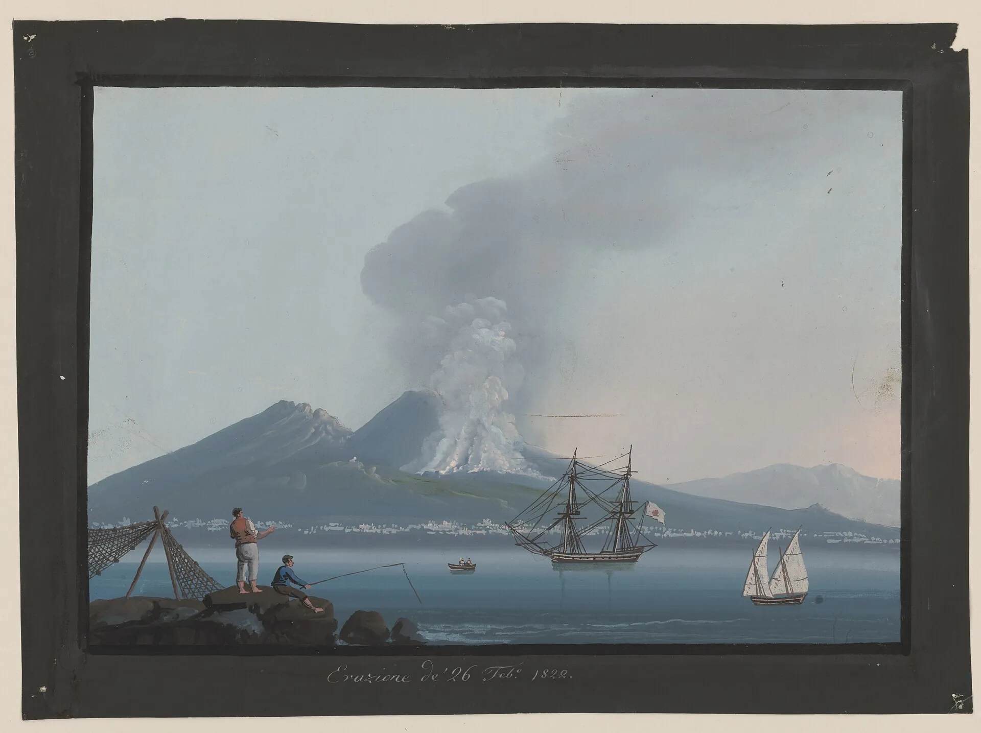
This is what it looked like in 1822, painted as a souvenir for travelers. Back then Vesuvius erupted almost constantly – until the conduit sealed in 1944. Since then: silence, fumaroles, 112 tiny earthquakes a month.
Photo: Gianni, Girolamo, 1837-1895, artist · Public domain
The last eruption of Vesuvius was in March 1944. Since then the conduit has been blocked, and the volcano counts as dormant, not extinct: fumaroles steam, and the Osservatorio Vesuviano counts about a hundred tiny earthquakes month after month. The alert level is green, and the monthly bulletin for August 2026 sees no sign of a significant development. Alert level, access rules and the crater hike: Mount Vesuvius.
The strongest had a magnitude of 1.6; almost all were beneath the crater in the uppermost kilometer, and 49 of them were below magnitude 0. In the twelve months before there were 1,059.
About 5 degrees above its mean; the thermal camera in the crater has measured locally rising surface temperatures since late June. INGV does not rate this as a significant development.
No ground deformation attributable to magma. The upper cone is slowly subsiding through gravity and settling; the tide gauge at Torre del Greco shows minus 6 cm since 2012.
Less than two days, about four cubic kilometers of ash and lapilli, no lava. The eruption of 79 AD is the most famous in history because an eyewitness described it and two towns preserved it. Its exact date is still not certain.
Magma meets groundwater, explosions open the conduit. A Plinian column rises over the mountain – about 25 kilometers (15 miles) high according to INGV, at times 32 according to Carey and Sigurdsson; the wind carries it southeast.
First pale, then gray pumice, in the end about three meters (10 feet) of it. Roofs give way under the weight; about 38 percent of the victims found in Pompeii died in this phase, mostly in collapsing houses.
The town lies to the west, outside the pumice fall. Here death comes at night: surges of about 400 °C (750 °F) moving at more than 80 km/h (50 mph) hit the people waiting for rescue in the boat houses on the beach. Herculaneum disappears under about 20 meters (65 feet).
The column collapses completely. Pyroclastic flows reaching 15 kilometers out finish off Herculaneum, Pompeii and Stabiae – in Pompeii many who had returned during the night die too. The dark cloud Pliny sees from Misenum belongs to this phase.
A large part of the old Somma volcano collapses. Today's cone later grows inside the caldera – the Vesuvius we know is younger than Pompeii.
August 24 appears only in the oldest surviving manuscript of Pliny's letters, from the 9th century; other copies give October 24 or November 1. Autumn is supported by autumn fruit, sealed wine vats, the victims' heavy clothing, braziers – and a charcoal inscription dated October 17, found in 2018. INGV now gives October 24, 79 AD; the Pompeii park calls it an open debate.
Found: 1,150 in Pompeii (Luongo et al. 2003), about 300 in the boat houses of Herculaneum. A third of Pompeii is unexcavated, and there are no figures for Stabiae and the countryside. The only defensible statement: at least about 1,450 deaths are documented, the true number is higher and unknown. The often-quoted "3,360" has no verifiable basis.
Two letters from Pliny the Younger to Tacitus, written years later. His uncle Pliny the Elder, commander of the fleet at Misenum, sailed to the rescue, could not land in the pumice fall and died on the beach at Stabiae. Eruptions of this type are called "Plinian" after him.
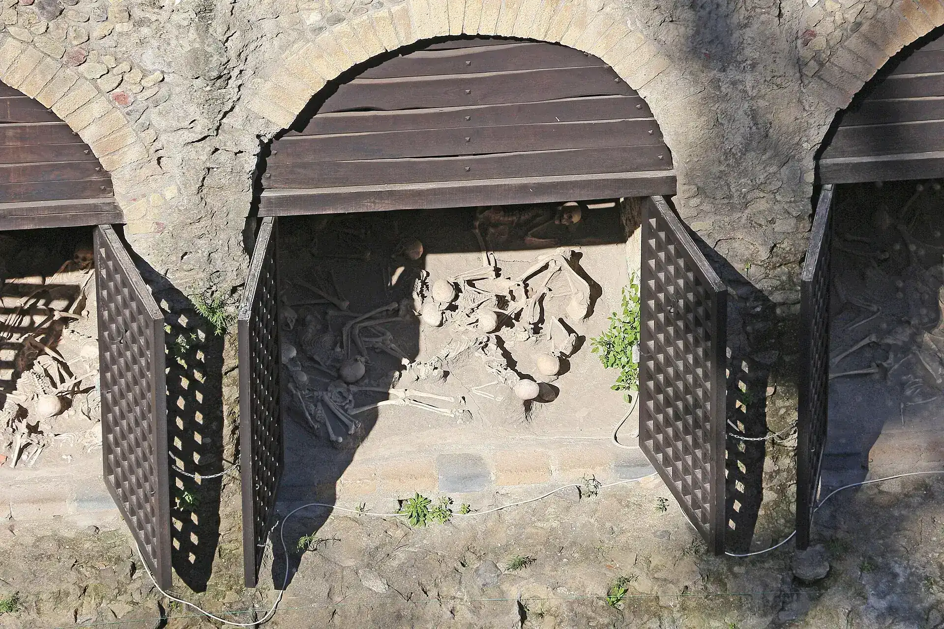
Photo: Bernard Gagnon · CC BY 4.0
The INGV catalog counts dozens of eruptions. Three shape the history: 79 AD, 1631 and 1944. In between lie 1,500 years of rare but violent events – and, from 1631 on, a period in which the mountain was almost constantly active. Here are the events with solid records.
On November 6, 472 the strongest eruption since 79 AD began, a sub-Plinian event. According to deposit studies the column reached 22 km at times; pyroclastic flows ran mainly northwest and southeast. Contemporary sources report ashfall as far as Constantinople; INGV mentions an ash layer of about 8 cm measured there. The pumice deposits reach about 30 km to the northeast; no figures for the dead survive. According to Sci Rep 2025 the eruption has a VEI of 4.
The chronicle of Montecassino (Leo Marsicanus) reports an unusually large fire that reached the sea. It is the first eruption after 79 AD for which lava is clearly documented.
After months of noticeable tremors and a rising crater floor, the eruption began on the morning of December 16, 1631 (INGV: around 7 am) with a sub-Plinian column 13 to 19 km high. On the morning of December 17 (around 10 am) the summit collapsed; pyroclastic flows raced down the flanks and reached the sea at Torre del Greco and Torre Annunziata, cutting off the escape route for the people on the coast. Heavy rain then triggered mudflows that ran up to 10 km.
The death toll is uncertain: civil protection gives more than 5,000, the INGV catalog 6,000 or 10,000. The cone lost about 450 meters in height. This eruption began an almost uninterrupted period of activity that lasted until 1944 – and it is the model for the reference scenario of today's emergency plan.
From June 15 to 24, 1794 vents opened on the west flank between 320 and 480 m. One lava flow ran through Torre del Greco and pushed about 100 m into the sea, a second flowed northeast; lava fountains and ash clouds at the crater. Torre del Greco was completely destroyed, about 15,000 inhabitants fled; damage 5 million ducats. To this day the bell tower of the basilica rises only as high as the church rebuilt on top of the lava. INGV gives no official death toll.
From October 21 to November 10, 1822: lava fountains up to about 2,000 m, a column about 4,000 m high and lava toward Boscotrecase. On the morning of October 24 Naples lay in darkness under reddish ash; weeks of rain mixed with ash triggered mudflows.
From April 24 to May 2, 1872 a fissure opened on the northwest flank; lava flowed toward Massa di Somma and San Sebastiano. A group of onlookers who had climbed up to the lava was suddenly hit by lava fragments; some of them died. According to the INGV catalog, 9 dead and 11 injured from the Strombolian activity, destruction in Massa di Somma and San Sebastiano. Palmieri stayed in the observatory, surrounded by lava, and kept observing.
On April 4, 1906 lava emerged on the south flank; Giuseppe Mercalli watched the onset at the summit. More vents opened, lava destroyed the Oratorio district of Boscotrecase and ran as far as the cemetery of Torre Annunziata. In the night of April 7 to 8 the explosive activity peaked and the summit collapsed; ash and lapilli fell to the east, above all on Ottaviano and San Giuseppe Vesuviano, and even reached Apulia. 216 dead, 112 seriously injured, 34,232 displaced (INGV after Nazzaro 1997). In Ottaviano and San Giuseppe alone 197 people died; in San Giuseppe a church roof collapsed with more than 150 people inside; in Naples the collapse of the Monteoliveto market roof killed 11. The funicular was destroyed. The cone sank from 1,335 m to about 1,100 m (east) and 1,200 m (west). Italy then gave up the 1908 Olympic Games, which London took over – officially because of the cost of the eruption; in fact the withdrawal had been decided beforehand (Olympedia).
On March 18, 1944 at 4:30 pm the eruption began with an explosion in the crater; two lava flows ran southeast and north. The northern one was deflected west by Monte Somma and reached San Sebastiano and Massa di Somma on March 21; Allied troops had moved about 7,000 people to safety beforehand. From March 21 to 22 eight lava fountains followed, then an ash column of more than 5 km (more like 10 km according to newer models) that carried loose material southeast. On March 29 the explosions ended; by April 7 the conduit was blocked. Victims: 21 according to civil protection, 23 according to INGV, killed by collapsing roofs; the INGV catalog gives 21 to 45 and stresses that there is no final figure. San Sebastiano and Massa di Somma were largely destroyed, about 10,000–12,000 people evacuated; Terzigno, Pompei, Scafati, Angri, Nocera, Poggiomarino and Cava suffered under the ashfall, and ash was carried up to 400 km (250 miles). At the "Pompeii" airfield near Terzigno/Poggiomarino the rain of lapilli and ash destroyed the B-25 bombers of the USAAF's 340th Bombardment Group – 88 aircraft according to the diary of a squadron member; nobody died there. CO₂ emissions (mofettes) continued for months afterwards.
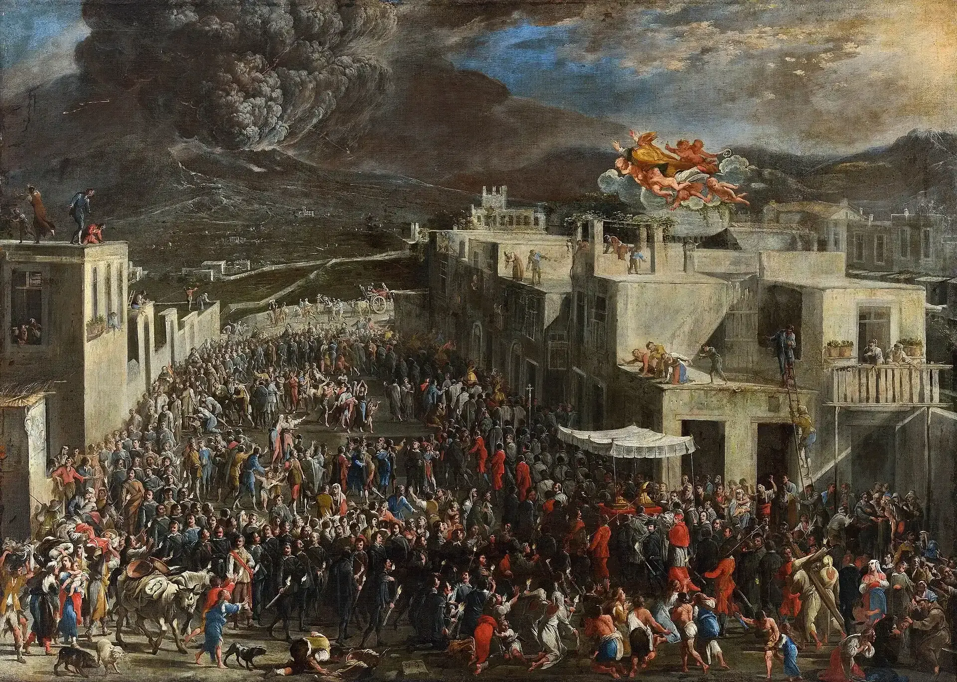
Photo: Domenico Gargiulo · Public domain
| 203 · 512 · 685 · 787 | 203: the historian Cassius Dio, who had a country house at Capua, reports a huge fire on Vesuvius and rumbling heard as far as Capua · 512: tax relief granted by Theodoric to the affected areas · 685 and 787: strong eruptions with lava fountains and long flows. |
| 1036/1037 · 1139 | Six days of lava, then in 1139 the last eruption before a rest of about 500 years – which ended in 1631 with the largest eruption since 79 AD. |
| 1660 to 1779 | Almost constantly active: black ash in 1660, lava on the outer slopes again in 1694, lava almost to the sea in 1698, ash over Naples in 1707, Torre del Greco hit in 1737 along with the first scientific report, fifteen small cones above Torre Annunziata in 1760, lava toward Portici in 1767, lava fountains kilometers high in 1779. |
| 1834 to 1861 | The longest lava flow in 1834, nine kilometers to Terzigno in 1850, a lava cascade into the Fosso della Vetrana in 1855, the ground rising at Torre del Greco in 1861. |
| 1913 to 1944 | The crater active almost without interruption, lava toward Terzigno in 1929. INGV divides the period 1631–1944 into 18 cycles, each ending with a more violent final eruption. |
1944 ended a period with an open conduit that had begun in 1631: as long as the conduit was open, magma escaped continuously in small eruptions. Since April 7, 1944 it has been blocked by rock from the crater wall. In rest periods like this, according to civil protection, magma accumulates at depth – and the rest periods of the past ended with high-energy eruptions, in 472 and 1631. That is why Vesuvius counts as dangerous even though there is nothing to see.
The most likely case if an eruption occurs: lava fountains, lava flows, ash on the nearest towns – roughly like 1944.
Like 1631: a column up to 19 kilometers, pyroclastic flows down to the sea. This is the case civil protection plans for, because it is frequent enough and its area also covers that of the smaller case.
Like 79 AD. A shallow magma chamber large enough for it has not been demonstrated geophysically. On present knowledge, which type will come could not be read from the precursors.
No authority gives a date. INGV writes that the next eruption cannot be predicted in the long term – but that monitoring can detect the precursors "well in advance": earthquake swarms, long-period earthquakes, tremor, ground deformation, changes in the gases. Civil protection states that there are currently no precursors. History shows how long the lead time can be: in 1631 people felt light tremors from June on, and in December the crater floor rose to the rim; in 1906 activity increased markedly from mid-March. According to a 2025 study, a long rest on its own says nothing certain about the strength of the next eruption. And "overdue" is a word from headlines, not from bulletins.
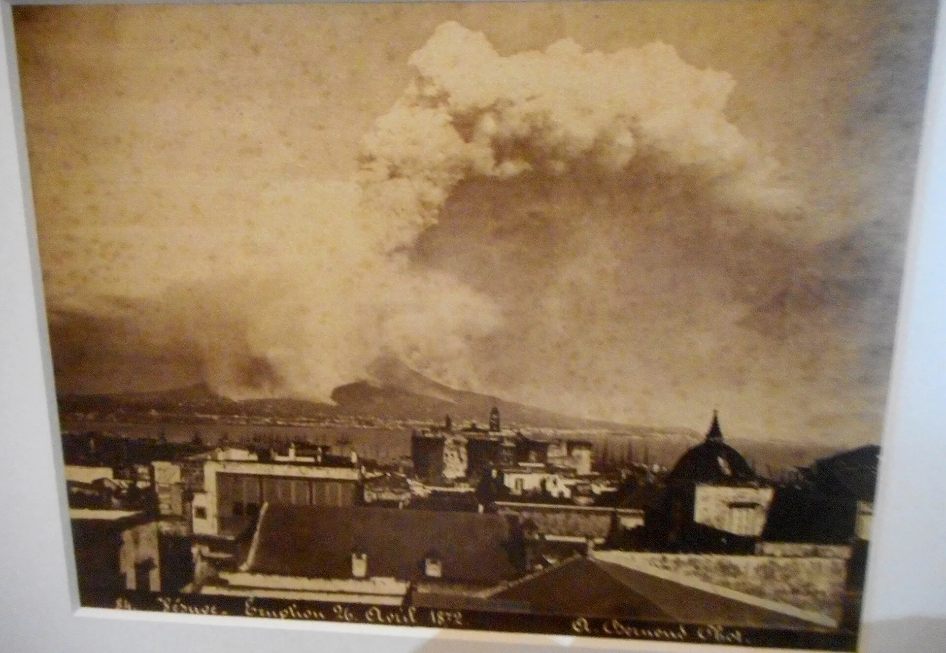
Photo: Carlo Raso from Naples, Italy · Public domain
The only protective measure for the red zone is evacuation before the eruption. The national plan (directive of February 14, 2014) provides for moving all residents out within 72 hours – simultaneously and in stages from every municipality, by bus to assembly points and on by train, bus or ship to partner regions all over Italy.
Boscoreale, Boscotrecase, Cercola, Ercolano, Massa di Somma, Ottaviano, Pollena Trocchia, Pompei, Portici, Sant'Anastasia, San Giorgio a Cremano, San Sebastiano al Vesuvio, San Giuseppe Vesuviano, Somma Vesuviana, Terzigno, Torre Annunziata, Torre del Greco, Trecase – and since 2014 Palma Campania, Poggiomarino, San Gennaro Vesuviano, Scafati, parts of Nola and the Naples districts of Barra, Ponticelli and San Giovanni a Teduccio. Zona rossa 1 is exposed to pyroclastic flows, Zona rossa 2 to roofs collapsing under ash. About 700,000 people on the slopes, 670,000 in the evacuation plan.
Areas that have to expect ashfall depending on the wind – here evacuation is decided only during the eruption. Naples lies in the red zone only with its eastern districts; the center belongs to the yellow zone.
| Green | Base level: nothing unusual compared with the activity seen over recent decades. Current status. |
| Yellow (Attenzione) | Monitoring is stepped up, emergency plans are reviewed. Earthquakes can already occur in this phase. |
| Orange (Preallarme) | The most demanding steps begin: hospitals and prisons are relocated, livestock and important cultural assets are moved to safety. Those who leave voluntarily receive a state allowance; access to the red zone is regulated. |
| Red (Allarme) | IT-alert message to every cell phone in Campania, evacuation of the entire red zone within 72 hours. An alarm does not necessarily mean an eruption will follow; the zone stays closed all the same, possibly for a long time. |
At the crater rim you see steam from fumaroles in the crater wall, otherwise no volcanic activity. The crater is about 450 meters (1,500 feet) wide and 300 meters (1,000 feet) deep; at the bottom lies the rock that sealed the conduit in 1944. To see the eruption of 79 AD, you don't climb the mountain – you go to the towns beneath it: to Pompeii for the casts of the victims in the Antiquarium and the Garden of the Fugitives, to Herculaneum for the boat houses on the beach. How to get up there: visiting Mount Vesuvius and Vesuvius tickets.
According to INGV; in 1906 the cone sank from 1,335 to 1,100–1,200 meters, in 1631 it lost about 450 meters. Every major eruption takes height off the mountain.
With a depth of 300 meters. The crater trail runs along the rim; entering the crater is prohibited.
March 18 to early April. 82 years of quiet since – the longest since 1631, but short against the 500 years before that.
In March 1944, in the middle of World War II: it began on March 18, the explosions ended on March 29, and by early April the conduit was blocked. Lava largely destroyed San Sebastiano al Vesuvio and Massa di Somma; collapsing roofs killed 21 people according to civil protection, 23 according to INGV.
Yes. It has been dormant since 1944 but is not extinct: fumaroles and weak earthquakes show that the system is alive. In August 2026 INGV recorded 112 earthquakes, the strongest of magnitude 1.6; the alert level is green.
Nobody can say – neither INGV nor civil protection gives a date or a probability for any time frame. What is certain is only that there are currently no precursors and that monitoring is meant to detect earthquakes, ground uplift and gas changes with lead time before an eruption.
1,150 dead were found in Pompeii, about 300 in the boat houses on the beach at Herculaneum. There is no reliable total, because a third of Pompeii is unexcavated and many died fleeing through the surrounding countryside.
Depending on the source, 14 to 32 km: INGV gives about 25 km, the classic reconstruction by Carey and Sigurdsson (1987) at times 32 km, the Herculaneum park administration 14 km. In less than two days about 4 km³ of ash and pumice were ejected.
For a long time August 24 was accepted, but that date comes from a medieval copy. A charcoal inscription of October 17 found in Pompeii in 2018 and autumn finds point to the fall; INGV now gives October 24, AD 79.
In Pompeii, plaster casts of victims and the Garden of the Fugitives show the consequences; in Herculaneum, the skeletons in the boat houses and the wall of solidified material meters high above the town. At the crater rim itself you see the cone, which grew only after AD 79 in the caldera of the old Monte Somma.
Beforehand: the alert level rises through yellow and orange to red; at red an IT-alert message goes to every cell phone in Campania and the red zone is evacuated within 72 hours. For the eruption itself the plan assumes a column several kilometers high, ash out to dozens of kilometers and pyroclastic flows on the slopes.
The city center lies outside the red zone; only parts of the eastern districts of Barra, Ponticelli and San Giovanni a Teduccio belong to it, and three districts lie in the yellow zone for ashfall. The level is currently green. The noticeable unrest in the region comes from the Campi Flegrei west of the city.
Civil protection speaks of about 700,000 people on the slopes of Vesuvius; the evacuation plan counts 670,000 residents of the red zone. It covers 25 municipalities, among them Pompei, Ercolano and Torre del Greco.
The one of AD 79 is the most famous and was among the strongest. Measured by recorded victims, 1631 was the most devastating of modern times with several thousand dead – civil protection gives more than 5,000. In the 20th century, 1906 claimed the most lives with 216 dead.
Several dozen times since AD 79. Between 1631 and 1944 it was almost constantly active; INGV divides that period into 18 cycles, each with a more powerful final eruption. Before 1631 came a long, but probably not entirely silent, pause since 1139.
After the 1944 eruption, rock from the crater wall blocked the conduit. Since then magma can no longer escape in small eruptions; in such rest periods, according to civil protection, it accumulates at depth. Quiet is therefore no sign that the volcano is extinct.
No. Long before an eruption, the red zone – which includes the crater – would be regulated, and at red it would be evacuated and closed. At which level exactly the crater trail closes is not set out in any official rule; today the park closes only for severe weather warnings.
Yes. The rain of ash hit the airfield of the US Army Air Forces' 340th Bombardment Group near Terzigno; according to a soldier's diary, 88 B-25 bombers were total losses. There were no deaths there; the unit had been evacuated on March 22.
Sources · accessed on 25 September 2026

.jpg)

.jpg)