Volcano·Guide
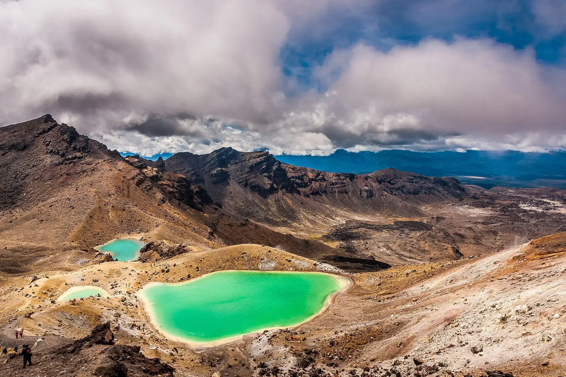
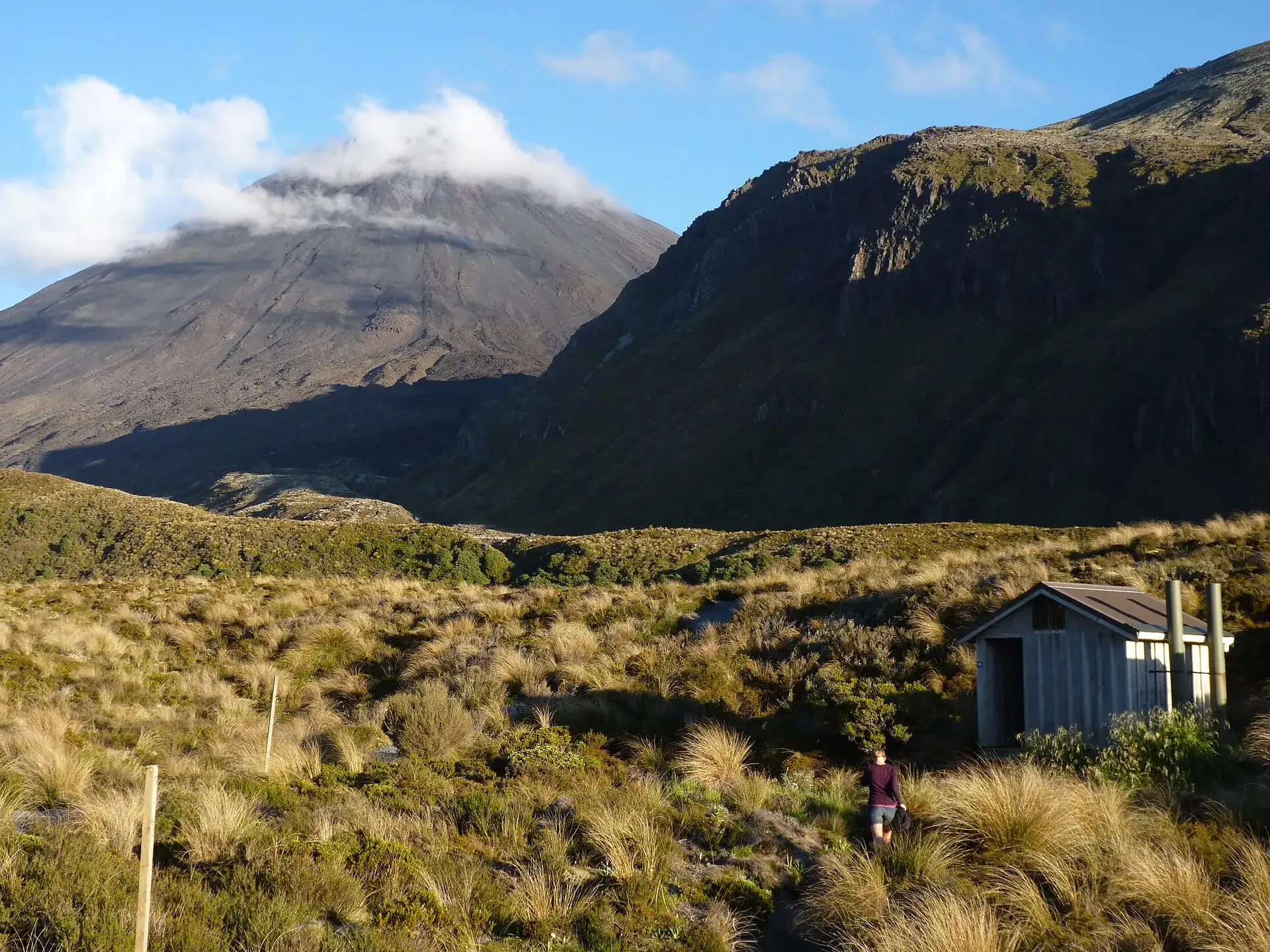
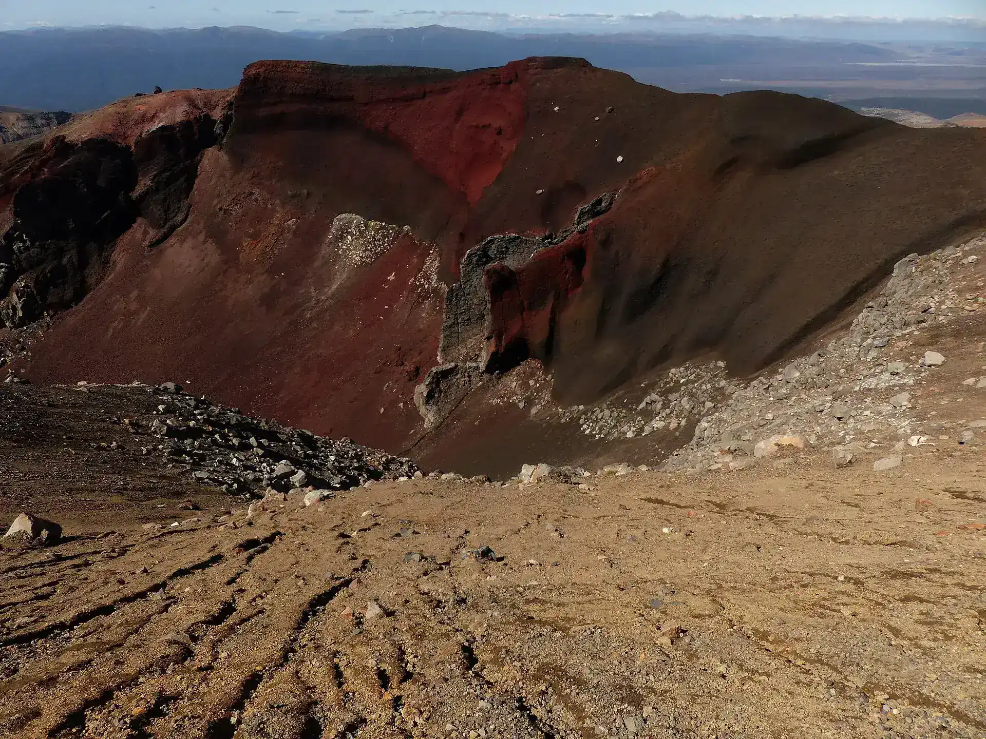
The Mangatepōpō valley in Tongariro National Park in the morning: tussock grass, a hut beside the track, and the cone of Ngāuruhoe behind it under a cap of cloud The Red Crater on Tongariro: a deeply cut, rust-red crater bowl with pale lapilli scree in the foreground The Emerald Lakes on the Tongariro Alpine Crossing seen from above: three bright green crater lakes among pale scree, clouds overhead

Tongariro Alpine Crossing

Morning in the Mangatepōpō valley. Tussock, a boardwalk, the cone of Ngāuruhoe above it.

A few hours later the ground is 1,886 m (6,188 ft) up – red, broken open, and steaming in places.

Then the descent over loose scree. The Emerald Lakes are at the bottom.

Scroll –
one day in three frames

As of 21 September 2026Tongariro Alpine Crossing today: open, alert level 0

The track is open. GeoNet reports Volcanic Alert Level 0 for Tongariro and Ngāuruhoe today and Level 1 for neighboring Ruapehu. What ruins the day here is not the volcano but the logistics: a four-hour parking limit at both road ends against seven to nine hours of walking.

The booking with the conservation agency DOC is free, and for anyone arriving under their own steam it is only recommended – it is compulsory solely for guests of shuttle and guiding operators. There is no quota, and DOC says nobody who turns up without a booking is penalised. An entry fee for international visitors is planned but not in force as of 21 September 2026.

Open
0Level

GeoNet's alert level

Tongariro and Ngāuruhoe sit at Volcanic Alert Level 0 ("no volcanic unrest"), Ruapehu at Level 1. GeoNet points out explicitly that an eruption can occur at any level and that the levels are not worked through in order. What remains are the hazards of the ground itself: hot fumaroles, unstable footing, gases.

GeoNet API, checked on 21 September 2026
Free
0NZD

The DOC booking

There has been a booking system since October 2023 – but no price and no cap. DOC's exact words: “There is no cost to book.” For all walkers the booking is recommended; it is required only if you use a shuttle or a guided trip. The advantage even without the obligation: short-notice warnings reach you directly.

bookings.doc.govt.nz · no penalty without a bookingNZ$0
Maximum stay
4hrs

Parking at the road ends

In the summer season both road ends have a four-hour maximum, and DOC says there is no parking at all for Crossing walkers at Mangatepōpō in summer. With seven to nine hours of walking the arithmetic does not work – the shuttle is not a convenience, it is the answer.

DOC: “we suggest you book a shuttle”
No fee yet

Access charge for foreign visitors

No, you pay no entry fee in 2026. The Conservation Amendment Bill needed for one was introduced on 7 May 2026 and had its first reading on 12 May – it has to become law first. The Crossing is one of four sites under consideration. What concessionaires may pass on today is the NZ$3 Community Contribution Charge.

State of the legislation on 21 September 2026NZ$3
rāhui
2,935ha

The 2025 burn

Two fires from 8 November 2025 burned about 2,935 hectares (7,250 acres) of tussock and alpine herbfield. The Crossing reopened on 17 November 2025; a ten-year restorative rāhui by Ngāti Hikairo ki Tongariro covers the burned area. The Mangatepopo Track stays closed – a DOC release of 4 September 2026 says it should return in mid-December 2026.

Stay on the track, clean your boots first, carry your rubbish out
May to October

Not a walking track in winter

The Crossing is not closed in winter – it only changes grade. From May to October DOC classifies it as an “Expert route”: crampons, an ice axe, a helmet, an avalanche transceiver, probe and shovel are essential, and so is practice with them. Shuttles generally do not run, and the daily weather advisory is not issued at all in those months.

Nine hours of walking with little daylight
Sources: DOC – Tongariro Alpine Crossing (parking limit, winter grade, weather advisory) · DOC – booking system since October 2023 (free, no cap, no penalty) · DOC – planned access charge (bill introduced 7 May 2026) · GeoNet, checked on 21 September 2026. Conditions change daily – check again before you travel.
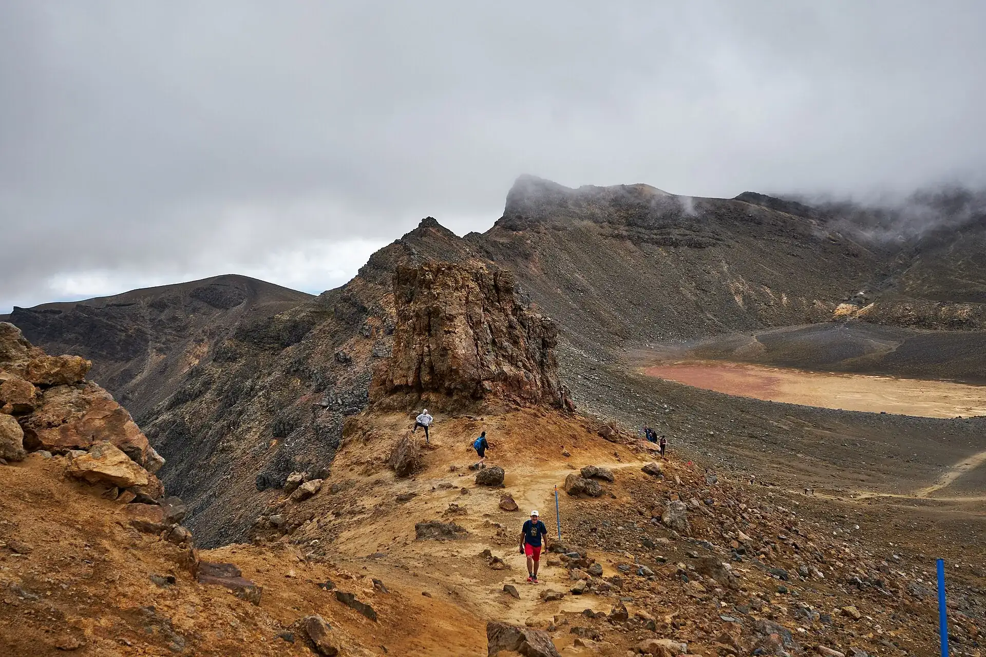
Walkers on the ridge at the Red Crater of the Tongariro Alpine Crossing: a narrow path over ocher rock, with the Central Crater behind under low cloud
Seven to nine hours. And no shortcut back to the car.

Photo: Luca Sartoni · CC BY-SA 2.0

What is actually out thereThe hike: Red Crater, Emerald Lakes, Blue Lake

The Crossing is not a loop but a one-way route from Mangatepōpō (1,120 m / 3,675 ft) to Ketetahi (760 m / 2,493 ft) – DOC gives 19.4 km (12.1 miles) in one place and 20.2 km (12.6 miles) on its main page for the same track. Both numbers are in circulation; what is settled is 1,196 m (3,924 ft) of elevation change and a high point at 1,886 m (6,188 ft).

The start is deceptive. The first few kilometers through the Mangatepōpō valley run over boardwalk and gravel, almost flat, with the cone of Ngāuruhoe on your right. After about 5.4 km (3.4 miles) the Soda Springs Walk branches off – the family option, roughly two hours return. Keep going and you soon face the steep climb to the South Crater, and the stroll turns into high mountain country.

The ground up there is different. At the Red Crater, 1,886 m (6,188 ft) up, the rock is rust red and broken open, steam comes out of the cracks, and the wind almost always hits you from the side. DOC does the math: on a calm day it is at least 10 °C (18 °F) colder here than in Taupō – and another 2 °C less for every 10 km/h of wind. You are not allowed to walk into the steam vents.

The descent from the Red Crater over loose lapilli scree is the most common accident spot on the route. Below it lie the Emerald Lakes, the green crater lakes DOC records as Ngā Rotopounamu; beyond the Central Crater comes the Blue Lake. The same rule covers all of them, and DOC states it plainly: “do not touch or enter any of the lakes.” The water is acidic, the ground geothermally unstable, and the lakes are subject to the rāhui.

Then comes the part nobody talks about: the long zigzag descent to Ketetahi Road, a thousand meters down, eventually just knees. There is no drinking water on the track – DOC requires 2 to 3 liters per person. Toilets come every one to two hours.

You can do it without a car, not without a shuttleTongariro Crossing shuttle: park and ride, not park and hope

The standard answer: leave your car in the paid private car park near Ketetahi, ride the shuttle about 30 minutes to the start at the Mangatepōpō road end – and finish the day at your own vehicle. Coming from Taupō, Tūrangi or Ohakune, you take a return shuttle that picks you up on Ketetahi Road in the afternoon. Operators with a DOC concession have to make sure their guests hold a booking, so the shuttle usually takes care of that too.

Affiliate links to GetYourGuide: if you book, we earn a commission and the price stays the same. Prices and ratings as of 21 September 2026. Whether you set off at all on a given day is decided by the weather at the Red Crater, not by the operator.

The rule behind the trackBooking, parking, fees: the Tongariro Crossing rules

The Crossing is one of the few major walks in the world with no gate, no ticket office and no opening hours. There are still rules – they just hang at the car park, in the weather forecast and in a request from the iwi rather than at an entrance.

Official prices · as of 09/2026 · NZ$1 ≈ US$0.61
Walking the Tongariro Alpine Crossing – no ticket, no gate, no opening hoursfree
DOC booking · required only if you use a shuttle or a guided tripNZ$0
Community Contribution Charge, paid to DOC per guest by concessionaires and passed onNZ$3 (about US$2)
Shuttle · the guide figure DOC givesabout NZ$40 (about US$25)
Planned access charge for international visitors · bill introduced 7 May 2026, not in forcedoes not exist in 2026
Sources: DOC – information for concessionaires (Community Contribution Charge of NZ$3, the booking obligation for guests, direction of travel Mangatepōpō → Ketetahi) and DOC – Sustainable Visitor Management for Tongariro. What the planned charge would cost and when it would start is not on the DOC consultation page – the figures circulating elsewhere are undocumented.

Four hours of parking, nine hours of walkingHow to organize the day

The order matters. Work out at the road end that your car cannot stay there and the day is already gone.

  1. Weeks aheadPick the shuttle – and with it the direction

    Park and ride from the private car park near Ketetahi is the version where the walk ends at your own car. Return shuttles from Taupō, Tūrangi or Ohakune are the answer without a rental car. The walk always runs Mangatepōpō to Ketetahi.

  2. Right after thatMake the DOC booking – it is free

    Through bookings.doc.govt.nz. With a shuttle it is compulsory; without one it is recommended. It costs nothing, there is no cap, and short-notice warnings reach you through it.

  3. The evening beforeRead the forecast for the Red Crater

    In the summer season DOC decides at 6 am each day whether to issue a “Not Recommended Today” advisory – triggered by, among other things, 55 km/h mean wind, 70 km/h gusts or a wind chill of −10 °C. From May to October there is no such advisory, so you read the forecast yourself.

  4. 5:30 to 8 amPark the car, take the shuttle

    Most buses leave at first light. Pack 2 to 3 liters of water – there is none on the track. Layers, waterproof trousers, hat and gloves: it is many degrees colder up top than in the valley.

  5. 7 to 9 hoursMangatepōpō → Red Crater → Ketetahi

    Do not turn off for the summits: the hapū Ngāti Hikairo ki Tongariro ask visitors not to climb the mountains in the national park, and DOC passes that request on. The signposts to the Ngāuruhoe summit were removed in 2017. Do not enter the lakes, do not enter the steam vents, stay on the track.

  6. AfternoonKetetahi road end

    With park and ride, your car is here. With a return shuttle this is the pick-up – get the time in writing beforehand. Anyone who cannot manage the route turns back early; the only sensible turning point is near the start.

Distances and timesRoutes and times: 19.4 km over the Red Crater

Every track in the park is free. What you pay for is the ride – and the prices below are operator figures, not official rates.

Route → what it takes, how long it lasts, what it costs
Tongariro Alpine Crossing · Mangatepōpō (1,120 m / 3,675 ft) → Ketetahi (760 m / 2,493 ft), high point 1,886 m (6,188 ft)One-way, 1,196 m (3,924 ft) of elevation change. DOC gives 19.4 km (12.1 miles) in one place and 20.2 km (12.6 miles) on its main page – both figures stand side by side. November to April 7 to 8 hours ("Intermediate tramping track"), May to October 9 hours ("Expert route"). Fitness required: high. Free.
Soda Springs Walk · from the Mangatepōpō road end · about 2 hours returnThe first 5.4 km (3.4 miles) of the Crossing, easy, as far as the springs at Te Tatau Pounamu. DOC names it for families and for anyone who does not want the full route. Note: you come back to your car – so the four-hour parking rule applies. Free.
Park and ride · private car park near Ketetahi → Mangatepōpō road end · about 30 minutesThe standard solution: the walk ends at your own vehicle. One operator quotes parking plus the ride from NZ$65 (about US$40) per adult, as of 09/2026. DOC's own general guide figure for a shuttle is about NZ$40.
Return shuttle from Taupō or Tūrangi · a full dayFrom Taupō about 10 hours from pick-up to return, from NZ$130 (about US$80); from Tūrangi about 9 hours, from NZ$110 (about US$68). Operator figures from September 2026. Shuttles generally do not run in winter – guided trips bring their own transport.
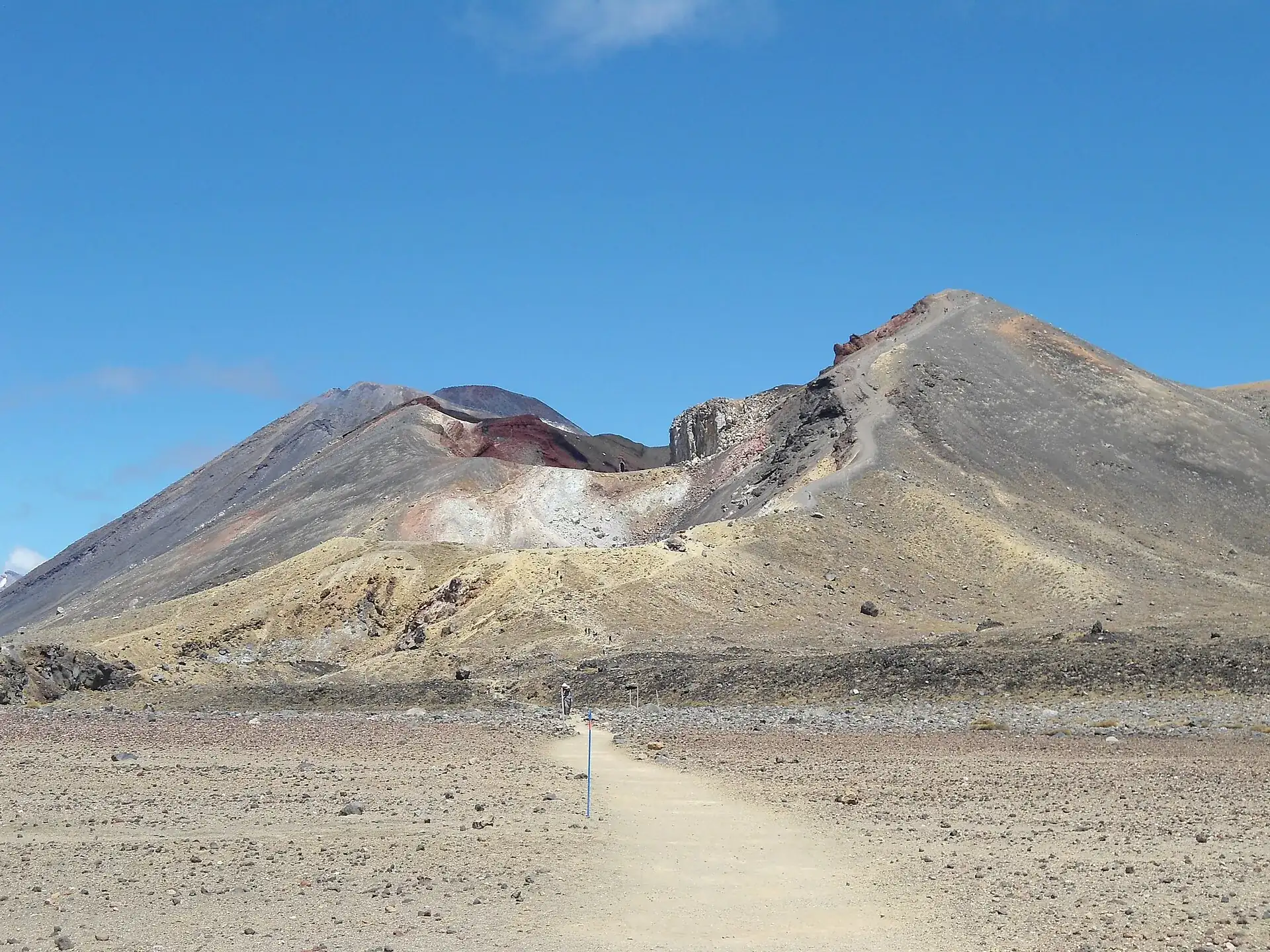
The Tongariro Alpine Crossing track crosses the flat Central Crater toward the Red Crater, with the cone of Ngāuruhoe behind it under a blue sky
The cone on the left is Ngāuruhoe. You walk past it, not up it.

Photo: Blueromulan · CC BY-SA 3.0

Good to knowGetting to the Tongariro Crossing, best time, tips

Getting there

Without a car: Daily long-distance coaches link Tongariro National Park with Ohakune, Waiouru, Waimarino (formerly National Park Village) and Tūrangi; shuttle buses pick passengers up from coaches and trains at Whakapapa Village and the neighboring settlements. Nothing scheduled runs to the track itself – only concessioned shuttles. Book through the i-SITEs: Ohakune 0800 647 483 (54 Clyde Street), Taumarunui +64 7 895 7494 (Railway Station), Tūrangi 0800 288 726 (Ngawaka Place), Taupō 0800 525 382 (30 Tongariro Street).

By car: This is the sticking point. DOC says there is no parking at all for Crossing walkers at the Mangatepōpō road end in summer, and both road ends have a four-hour maximum. If you are out for seven to nine hours you cannot legally leave your car there. The usual answer: park in the private, paid car park near Ketetahi and take the park-and-ride shuttle to the start – so the walk ends at your own car. DOC advises against parking on the shoulder of the state highways.

  • From Whakapapa Village · about 20 minutes
    via SH 48 and SH 47 to the Mangatepōpō road end; shuttle
  • From Waimarino / National Park Village · about 25 minutes
    SH 47, shuttle or park and ride
  • From Tūrangi · about 45 minutes
    SH 41 / SH 47, return shuttle from the town center
  • From Raetihi · about 50 minutes
    SH 4 / SH 47
  • From Ohakune · about 55 minutes
    SH 4 / SH 47, shuttle booked through the i-SITE
  • From Taumarunui · about 1 hour
    SH 4 / SH 47
  • From Taupō · about 1.5 hours driving; a shuttle day runs about 10 hours
    SH 1 and SH 47, or a return shuttle from the town center
  • From Auckland · 4–5 hours
    SH 1 / SH 47; DOC gives 4–5 hours' driving to the national park
  • From Wellington · 4–5 hours
    SH 1 / SH 4; DOC gives 4–5 hours

Best time to go

The summer season (Labour Weekend in late October to 30 April), on a day without a 'Not Recommended Today' advisory. Start early: the shuttles run at first light, and wind and thunderstorms build in the afternoon. From May to October there is snow and ice, DOC issues no weather advisory, regular shuttles do not run, and there are only 9 to 11 hours of daylight for 9 hours of walking – so the trip becomes an alpine undertaking with crampons, ice axe, helmet and avalanche gear, or a job for a guided group. Since the 2025 fire you see blackened slopes near the start; DOC points out that new growth is already coming through beside them.

Who it suits

Children
DOC: 'This track is not recommended for children under the age of 10.' The reason: exposed alpine terrain and often rough weather. For families DOC names the Soda Springs Walk (2 hours) instead.
Minimum age
no formal minimum age, but DOC recommends 10 and over
Fitness
DOC grades it 'Fitness required: High' and the terrain 'steep and undulating'. 20.2 km (12.6 miles), 1,196 m (3,924 ft) of elevation change, 7 to 9 hours. The descent from the Red Crater runs over slippery lapilli scree, and the long zigzag down to Ketetahi Road is hard on the knees.
Heart and lungs
Geothermal fumaroles release gases; DOC requires visitors to stay out of steam vents. Anyone with a heart or lung condition should be realistic about seven to nine hours of sustained effort.
Wheelchair
Not suitable. The opening stretch in the Mangatepōpō valley is boardwalk, the rest is steps, scree and gravel.
Dogs
Not allowed. DOC: 'No dogs are allowed in Tongariro National Park', including Whakapapa Village, the ski areas and inside your car. The park boundary starts at the SH 47 / SH 48 junction.
Clothing
Layers: thermal base layer (polypropylene or merino), fleece or wool for insulation, waterproof shell. Plus waterproof trousers, hat, gloves, sun protection. In winter add crampons, an ice axe, a helmet, an avalanche transceiver, probe and shovel – and the skill to use them.
Footwear
Sturdy hiking boots, or mountaineering boots in winter. DOC cites the figure that 38 percent of tramping injuries come from slipping. Carry 2 to 3 liters (about 2 to 3 quarts) of drinking water – DOC says the water along the track is not drinkable.

Tips you will need on site

  • Leave your car in the paid Ketetahi car park and take the park-and-ride shuttle to the start. The walk then ends at your own vehicle – and you sidestep the four-hour parking rule at the road ends.
  • Book even without a shuttle: it is free, there is no quota, and DOC uses it to send short-notice warnings straight to walkers.
  • Check the NIWA forecast for the Red Crater and the DOC alerts the evening before. If a 'Not Recommended Today' advisory is in force, the sign only goes up at the Mangatepōpō road end – by then the shuttle is already paid for.
  • Pack 2 to 3 liters of water. There is no drinkable water on the track, and you are not allowed to touch the crater lakes.
  • There are toilets every one to two hours. If there is a queue at the start, the next one is only 1 km, or 20 minutes, further on.
  • The descent from the Red Crater over loose scree is the most common accident spot. Poles help, and so do small steps and keeping your distance from the person ahead – stones roll.
  • Do not turn off for the summits of Ngāuruhoe or Tongariro. Local iwi ask visitors not to, and DOC removed the signposts to the Ngāuruhoe summit in 2017.
  • Clean your boots and gear before you come. DOC names this explicitly as a contribution to the rāhui – so that no weed seeds are carried into the burned area.
  • Leave dogs at home: they are not allowed in the park from the SH 47 / SH 48 junction onwards, not even inside the car.

A short history

  • In 1887 Te Heuheu Tūkino IV, ariki of Ngāti Tūwharetoa, made the mountain peaks sacrosanct to the Crown – DOC's phrasing – with the intention that the Crown and Ngāti Tūwharetoa would stand together for the protection of Tongariro.
  • In 1894 that became Tongariro National Park, New Zealand's first and, DOC says, the fourth in the world (Wikipedia counts it as the sixth – the methods of counting differ).
  • In 1990 the park joined the UNESCO World Heritage list for its natural values; in 1993 it became the first site in the world to be listed additionally under the revised criteria for cultural landscapes. The spiritual significance of these mountains is recognized in international law.
  • Ngāuruhoe, the striking cone beside the track, is geologically not a mountain of its own but a vent of the Tongariro complex, and only about 2,500 years old. Its last eruption sequence was in 1975/77.
  • In 2007 DOC renamed the 'Tongariro Crossing' the 'Tongariro Alpine Crossing' – the word 'alpine' was meant to make clear that this is high mountain country, not a stroll.
  • On 6 August 2012 the Te Maari Crater on Tongariro erupted and threw out about 10,000 cubic meters of ash; Ketetahi Hut was hit by blocks. A second eruption on 21 November 2012 sent an ash cloud to 4,000 m (13,000 ft). The track was closed each time.
  • Visitor numbers rose from about 10,000 in 1990 to more than 100,000 – the reason for parking restrictions, the booking system introduced in October 2023, and joint management with Ngāti Hikairo ki Tongariro.
  • On 8 November 2025 two fires broke out in the park and burned about 2,935 hectares (7,250 acres) of tussock, alpine herbfield and cushion bog. Ngāti Hikairo ki Tongariro placed a rāhui over the maunga; the Crossing reopened at 9 am on 17 November 2025. A ten-year restorative rāhui covers the burned area. The pou Te Ririo survived the fire – spokesman Te Ngaehe Wanikau: 'Our pou, Te Ririo, still stands.'

May to October, and for anyone who would rather not go aloneTongariro Crossing in winter: expert route, not a walk

From May to October there is snow and ice on the route, DOC requires alpine equipment and the skill to use it – and issues no bad-weather advisory at all in those months. If you want to go then, you go guided. Guided options exist in summer too, along with the half route to Soda Springs.

Affiliate links to GetYourGuide: if you book, we earn a commission and the price stays the same. Prices and ratings as of 21 September 2026. Which winter equipment a guided trip supplies and what you have to bring yourself is not in every listing – ask before you book.

Outdated onlineWhat other sites get wrong

“You park at the Mangatepōpō road end and just set off.”
Both road ends have a four-hour maximum in the summer season, and DOC says there is no parking at all for Crossing walkers at Mangatepōpō in summer. With seven to nine hours of walking, the shuttle is the only option left.
“The Crossing is a loop – you end up back at your car.”
It is a one-way route from Mangatepōpō (1,120 m) to Ketetahi (760 m). Without organized transport or park and ride you finish the day about 25 road kilometers (16 miles) from your vehicle.
“Climbing Mount Doom is part of the Crossing.”
The Ngāuruhoe summit is sacred to Ngāti Hikairo ki Tongariro. DOC passes on the iwi's request not to climb the mountains in the national park and removed the summit signposts in 2017. It is not a legal ban – it is a request from the place itself.
“Booking is compulsory and costs money.”
Both wrong. DOC: “There is no cost to book”, and anyone turning up without a booking is not penalised. It is compulsory only for guests of shuttle and guiding operators.
“International visitors have paid a fee for the Crossing since 2025.”
As of 21 September 2026 there is no such fee. The bill needed for it was introduced on 7 May 2026 and had its first reading on 12 May. All that may be passed on today is the NZ$3 Community Contribution Charge.
“You can cool your feet in the Emerald Lakes.”
DOC forbids it in plain words: “do not touch or enter any of the lakes”. The water is acidic, the ground geothermally unstable – and the lakes are subject to the rāhui.

Quick answersBefore the hike

In what order do I book the shuttle and the DOC place?

The shuttle first, because it fixes the direction and the start time. The DOC booking comes afterwards and costs nothing. Concessioned operators have to make sure their guests are booked – some make the booking for you, some do not. When in doubt, make it yourself: a duplicate harms nobody, and there is no cap.

What happens if I overrun the four-hour parking limit?

DOC states the rule but gives neither a fine nor a procedure. Travel sites write about wheel clamps and towing – that is not officially documented, so it is not stated as fact here. In practice the question is academic anyway: seven to nine hours of walking do not fit into four hours of parking.

Can I walk only half the Crossing?

Partly. From the Mangatepōpō road end the Soda Springs Walk follows the first 5.4 km (3.4 miles) of the Crossing to the springs and back, about two hours, easy. DOC names it as the family option and the turn-back option in poor weather. Past the South Crater there is no sensible way back.

What is a rāhui, and what does it mean for me on the track?

A rāhui is an access or use restriction placed by the iwi – here to protect the burned area. Ngāti Hikairo ki Tongariro placed it on 9 November 2025, and it covers the burn for ten years. For walkers that means: stay on the track, do not walk into the burned area, clean your boots and gear beforehand, carry your rubbish out.

Is the Tongariro Alpine Crossing worth it in bad weather?

No. The route runs for hours above 1,800 m (5,900 ft) with no shelter; in wind and rain you see nothing and cool down fast. That is why DOC issues its own “Not Recommended Today” advisory in summer. If one is in force, the shuttle is usually already paid for – though operators normally rebook when the weather is uncertain.

Do I have to book the Tongariro Alpine Crossing in advance?

Partly. DOC has run a free booking system since October 2023. For all walkers the booking is recommended; it is compulsory for guests of shuttle or guiding operators. Anyone turning up without one is not penalised, according to DOC, and there is no quota.

What does the Tongariro Alpine Crossing cost?

The walk itself is free, and so is the booking. What you pay for is transport: park and ride from about NZ$65 (about US$40), a return shuttle from Tūrangi from NZ$110, from Taupō from NZ$130 – operator prices as of September 2026. DOC gives a guide figure of 'about NZ$40' for a shuttle and may collect NZ$3 per guest through concessionaires as a Community Contribution Charge.

Do foreign visitors have to pay an entry fee in 2026?

No. An access charge for international visitors is planned but not in force. The Conservation Amendment Bill needed for it was introduced on 7 May 2026 and had its first reading on 12 May 2026. The Crossing is one of the four sites under consideration, alongside Cathedral Cove, Aoraki/Mount Cook and Milford Sound.

Can I park at the start?

Not for the whole walk. Both road ends have a four-hour maximum in the summer season, and DOC says there is no parking at Mangatepōpō for Crossing walkers in summer. The usual approach is to park in the private car park near Ketetahi and take a shuttle to the start.

How long does the Tongariro Alpine Crossing take?

DOC gives 7 to 8 hours from November to April and 9 hours from May to October. The route is 20.2 km (12.6 miles) long with 1,196 m (3,924 ft) of elevation change, from the start at 1,120 m (3,675 ft) over the Red Crater at 1,886 m (6,188 ft) and down to Ketetahi at 760 m (2,493 ft).

Am I allowed to climb Mount Doom (Ngāuruhoe)?

The hapū Ngāti Hikairo ki Tongariro ask visitors not to climb the mountains in the national park, and DOC passes that request on across its pages. The signposts to the Ngāuruhoe summit were removed in 2017. It is not a legal ban, but anyone who wants to travel respectfully leaves it alone.

Is the walk possible in winter?

Yes, but as an alpine trip. From May to October DOC grades the track an 'Expert route': snow, ice, avalanche terrain and sub-zero temperatures. You need crampons, an ice axe, a helmet, an avalanche transceiver, probe and shovel – and practice with them. Shuttles generally do not run in winter; guided trips bring their own transport.

How do I know whether the weather is good enough?

In the summer season DOC decides at 6 am each day whether a 'Not Recommended Today' advisory applies. It kicks in at, among other thresholds, 55 km/h mean wind, 70 km/h gusts or a wind chill of −10 °C. The advisory appears on the NIWA forecast for the Red Crater and on a sign at the Mangatepōpō road end. From May to October there is no such advisory.

Is the volcano dangerous right now?

As of 21 September 2026 GeoNet reports Volcanic Alert Level 0 (no volcanic unrest) for Tongariro and Ngāuruhoe and Level 1 (minor unrest) for Ruapehu. GeoNet does point out that an eruption can occur at any level. DOC puts it plainly: if you are not willing to live with that residual risk, choose a different track.

How does the 2025 fire affect the walk today?

The Crossing is open. Two fires from 8 November 2025 burned about 2,935 hectares; the track was closed for a week and reopened on 17 November 2025. Near the start you see blackened slopes and the first new growth. A ten-year rāhui covers the burned area: stay on the track, do not walk into the burn, clean your boots beforehand, take your rubbish with you.

Is the Crossing suitable for children?

DOC advises against the route for children under ten – the terrain is exposed and the weather often rough. Families with younger children take the Soda Springs Walk instead, which shares the first few kilometers and takes about two hours return.

Is there water and are there toilets along the way?

DOC says there are toilets every one to two hours. There is no drinking water: the water along the track is not drinkable, which is why DOC requires 2 to 3 liters per person. The crater lakes must not be entered or touched.

Can I bring my dog?

No. Dogs are banned throughout Tongariro National Park, including Whakapapa Village, the ski areas and inside your car. The park boundary begins at the State Highway 47 / State Highway 48 junction.

How do I get there from Auckland or Taupō?

DOC gives 4 to 5 hours' driving from Auckland and from Wellington to the national park. From Taupō (86.5 km / 54 miles) concessionaires run return shuttles covering the whole day – about 10 hours from pick-up to return. Long-distance coaches run daily to Ohakune, Waiouru, Waimarino and Tūrangi; nothing scheduled goes to the trailhead itself.
Sources · accessed on 21 September 2026