Volcano·Guide
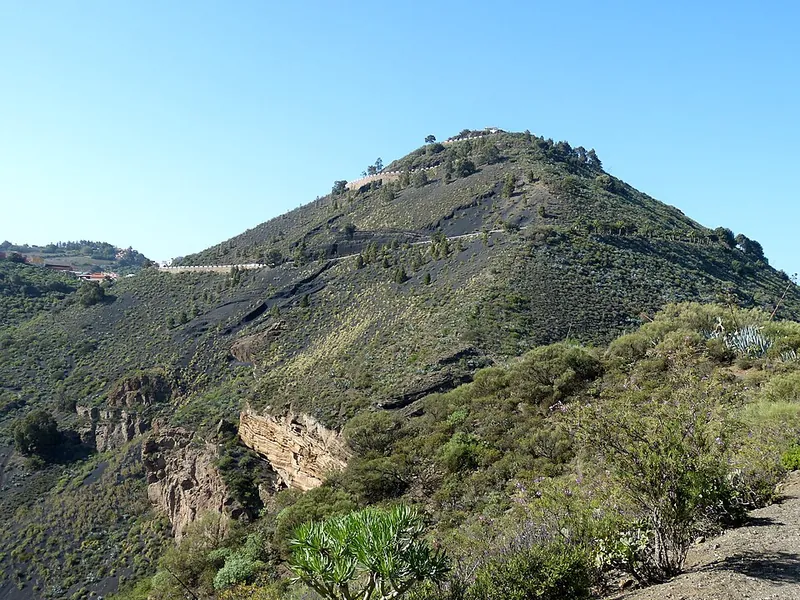
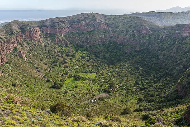
The green cinder cone Pico de Bandama on Gran Canaria, in front of it the vegetated rim of the Bandama crater View from the Pico de Bandama into the Caldera de Bandama: steep walls of reddish-brown lapilli, the green crater floor below View from the Pico de Bandama north over Tafira and Las Palmas to the Atlantic

Caldera de Bandama

From below, a green cone among vineyards.

At the top the ground drops away: 650 feet deep, more than half a mile across.

And beyond it, Las Palmas and the sea.

Scroll –
up to the Pico

As of September 22, 2026Everything is free – no ticket, no reservation, no guide

Twenty minutes from Las Palmas lies the youngest volcano on Gran Canaria. The viewpoint, the crater rim and the hike down into the caldera are free and need no booking – the only rule of the protected area is to stay on the marked trails. What does need a reservation is Roque Nublo in the center of the island.

Open
1,883ft

Mirador Pico de Bandama

Road up to the summit parking lot, open around the clock. 360-degree view over the caldera, Las Palmas, the northeast coast and the center of the island. Since April 2024 no vehicles over 3.5 t may drive up.

parking free€0
Open
560ft down

Hike into the caldera

Camino de Agustinito from the Caserío: a good hour there and back, old farmsteads, a wine press and grain caves at the bottom. The gate says 8 am–5 pm; according to press research it is no longer locked.

no ticket, no guide€0
Reservation
5,948ft

Roque Nublo (side trip)

Since February 2025 daytime access only with a free QR reservation on grancanariasenderos.com, at most 60 people per hour. The old parking lot is gone – shuttle from Tejeda or Cruz de Los Llanos.

reservation free€0
Sources: Patronato de Turismo de Gran Canaria (grancanaria.com), Gobierno de Canarias (SAC ES7010012, management plan PG-GC-14 since 04/2016), Cabildo de Gran Canaria (ban on vehicles over 3,500 kg since April 16, 2024; Roque Nublo access rule since February 3, 2025), Canarias7 (gate at the descent, 07/2022). During wildfire alerts the Cabildo closes trails across the island – current notices at cabildo.grancanaria.com.
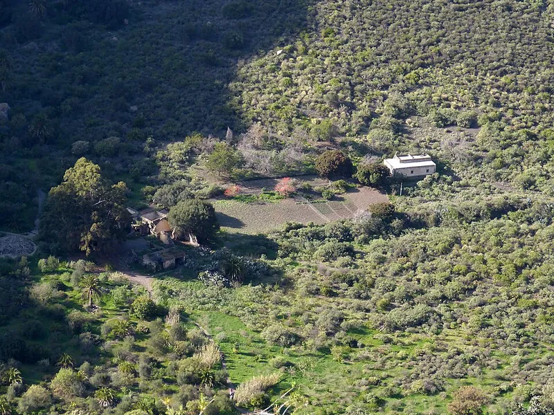
View from above onto the crater floor of the Caldera de Bandama: fields, palms and the old farmsteads among bushes
Farmers lived at the very bottom into the 20th century. The trail leads exactly there.

Photo: Wolfgang Sauber · CC BY-SA 4.0

The experienceDown into the funnel

The trail starts paved and quickly turns to earth and loose volcanic cinder. With every switchback the walls close in, the wind stays above, it goes quiet. On the crater floor stand the Casa de los Marrero, an old wine press, a threshing floor and caves from pre-Hispanic times – all around, 650 feet of lapilli, and above, a circle of sky. The climb back up is the hard part: 560 feet in the sun, so go in the morning.

Affiliate links to GetYourGuide: if you book, we earn a commission and the price stays the same. Prices and ratings as of 22 September 2026. Nobody needs a tour for Bandama itself – these make sense if you have no car or want to combine city, garden and crater in one day.

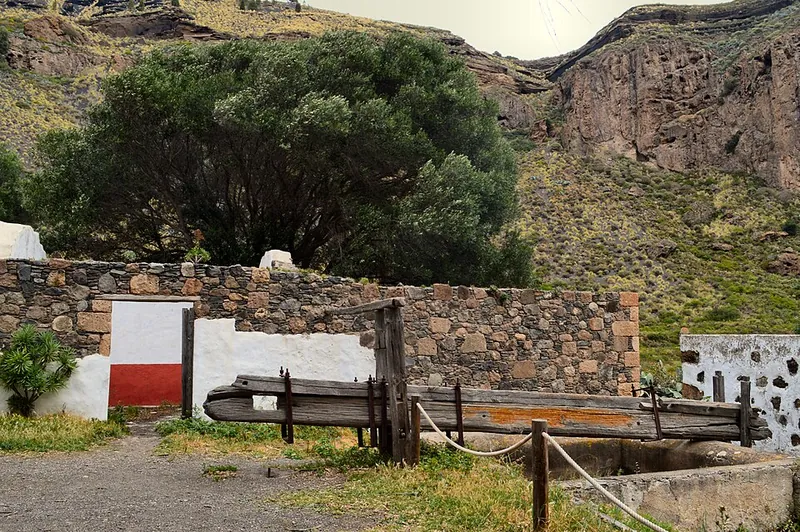
Old stone wine press with wooden beams in front of a white-and-red farmhouse wall on the crater floor of the Caldera de Bandama
The wine press on the crater floor: Gran Canaria's winegrowing began here in the 16th century – on lapilli, planted by a Fleming named van Damme.

Photo: AndyScott · CC0

The rulesWhat applies – and what does not

Bandama is a Monumento Natural and a European protected area, but there is no admission, no quota and no mandatory guide. The few rules are posted along the trail.

1

Stay on the trail

The lapilli ground gives way, and signs warn of rockfall on the crater walls. Do not cross the barriers on the rim – that is the one rule the Cabildo enforces.

2

Gate 8 am–5 pm

That is what the sign at the start of the descent says. According to Canarias7 (2022) the gate is in practice no longer locked. Do not count on it: be back up before 5 pm.

3

Wildfire alert = closure

During an Alerta por incendios in summer the Cabildo de Gran Canaria closes trails and recreation areas across the island, at short notice and without exception.

4

No vehicles over 3.5 t

Since April 16, 2024 the road to the Pico is closed to vehicles over 3,500 kg – motorhomes of that class included. Pedestrians and cyclists are free to go.

Official prices · as of 09/2026
Admission to the caldera, crater rim and viewpointfree
Parking at the Mirador Pico de Bandama and at the Caseríono fee documented
Roque Nublo: reservation via grancanariasenderos.comfree
Roque Nublo: shuttle Global line 18 from Tejeda / Cruz de Los Llanosstandard Global fare
Sources: Gobierno de Canarias (biodiversidadcanarias.es, conservation rules), Cabildo de Gran Canaria (environment department; Roque Nublo regulation). We could not document the fare of bus line 311; it is the standard Global fare.
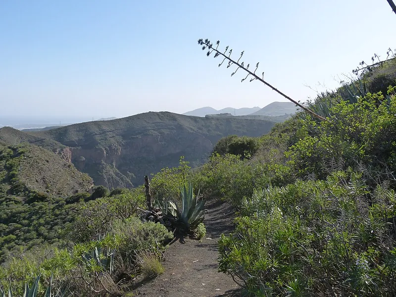
The hiking trail on the rim of the Caldera de Bandama between agaves and bushes, the crater wall behind
The rim: 2 miles once around, exposed in places – and past the golf course, the oldest in Spain.

Photo: Wolfgang Sauber · CC BY-SA 4.0

TrailsDown, around, up

Three options, all starting at the Caserío de Bandama on the GC-802 – which is also where the bus stops.

The trails · as of 09/2026
Descent into the caldera (Camino de Agustinito) · from the gate at the CaseríoAbout 560 ft (170 m) down and back up, about 1 hour of walking, 1.5–2 hours with a loop of the crater floor. Paved at first, then earth and lapilli, slippery in places. Free.
Loop trail on the crater rim (Borde de la Caldera)2 miles (3.2 km), about 1 hour 20 minutes, moderate because of exposed sections. Combined with the descent as one big loop: 4.7 miles (7.5 km), about 3 hours, 1,250 ft (380 m) of climbing.
Road to the Mirador Pico de Bandama (1,883 ft / 574 m)From the Monte Lentiscal roundabout via La Atalaya and the Caserío, about 20 minutes' drive from Las Palmas. On foot from the Caserío 30–40 minutes along the road. Parking at the top is free.
Sources: Canary Islands tourism (holaislascanarias.com), Patronato de Turismo de Gran Canaria, IGME (inventory of geological sites IC3030: descent on foot only, not wheelchair-accessible).
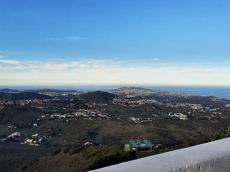
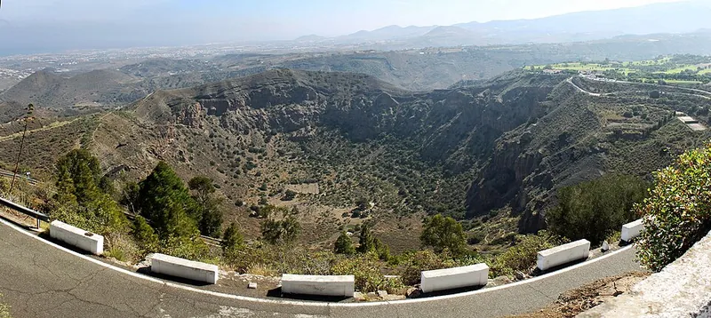
Panorama from the Mirador Pico de Bandama: the circular Caldera de Bandama, beyond it Tafira, Las Palmas and the sea
From the viewpoint you see the whole funnel at once – and how close the city has already come.

Photo: H. Zell · CC BY-SA 3.0

Good to knowGetting there, best time, tips

Getting there

Without a car: Global bus line 311 Las Palmas (Estación San Telmo) – Tafira – Jardín Canario – Bandama – Santa Brígida, roughly hourly on weekdays (5:55 am–8:55 pm from San Telmo), about every two hours on Saturdays and holidays. The Bandama stop is at the Caserío, right at the start of the descent; to the viewpoint you continue on foot. From Santa Brígida about 12 minutes.

By car: Via the GC-4/GC-15 to Monte Lentiscal, then the GC-802 through vineyards to the Caserío de Bandama and on to the Pico. Parking at the Caserío (also at the golf club) and at the viewpoint, free, full on weekends. Vehicles over 3,500 kg have been banned from the Pico since April 2024. The Cabildo plans to close the summit road to private traffic and run a shuttle (Plan Integral, announced in 2019, confirmed again in 2024, not implemented as of 09/2026).

  • From Las Palmas de Gran Canaria · 20 minutes by car, about 40 minutes by bus
    Car via GC-4 and GC-802, or bus 311
  • From Maspalomas / Playa del Inglés · about 1 hour by car
    GC-1 to Las Palmas, then GC-4/GC-802; by bus change in Las Palmas (San Telmo) to line 311
  • From Gran Canaria Airport · about 30 minutes
    GC-1 toward Las Palmas, exit Telde/Tafira or via Monte Lentiscal

Best time to go

Mornings before 11 am: cooler for the climb back up, the trade-wind cloud usually has not settled over the center of the island yet, and parking at the Caserío is free. Clearest views in winter after rain; spring for the flowers in the crater. Avoid summer afternoons (heat, wildfire warnings). Sunset from the viewpoint is popular, but then no more descent.

Who it suits

Children
The viewpoint is doable for everyone. The descent is short but steep and slippery – fine with children from elementary-school age, strollers are out.
Minimum age
none
Fitness
Low for the viewpoint and the rim, moderate for the descent: 170 m (560 ft) down and back up, strenuous in the sun.
Heart and lungs
no official restrictions; the climb back up is the strenuous part
Wheelchair
The viewpoint is reachable from the parking lot; according to the IGME inventory the descent trail is not wheelchair-accessible
Dogs
No Bandama-specific rule documented; usual in Canarian protected areas: on a leash.
Clothing
Sun protection, hat, water; it can be windy on the rim
Footwear
Hiking shoes with tread – the lapilli ground on the descent is loose

Tips you will need on site

  • Down first, then up: into the caldera in the morning, afterwards by car or on foot up the Pico – the other way round you stand in the crater in the midday heat.
  • Bring water; there is no spring for visitors and no kiosk in the crater.
  • Do not climb over the barriers on the crater rim – the lapilli ground gives way, and the Cabildo explicitly warns of rockfall.
  • Without a car: bus 311 to the Bandama stop, do the descent and walk up the road to the viewpoint; check the timetable for the return, on Saturdays the bus runs only every two hours.
  • Do not drive a motorhome or minibus over 3.5 t up to the Pico – banned since April 2024, and there is little room to turn at the top.
  • On the rim loop watch for golf balls: the trail runs along the course.
  • Roque Nublo on the same day? Reserve there in advance (free, QR code), otherwise no access between 9 am and 5 pm.
  • In summer read the Cabildo's wildfire warnings; during an alert trails are closed across the island.

A short history

  • The Bandama eruptive complex formed in several phases; its beginning is placed 4,000–5,000 years ago, the last dated eruption (IGME) at 1970 ± 70 years before present – the youngest on Gran Canaria.
  • Geologically the caldera is a maar: magma met groundwater, and the phreatomagmatic explosions blew open the funnel about 1,000 m (3,300 ft) wide and over 200 m (650 ft) deep; the Pico is the Strombolian cinder cone of the same phase.
  • The name goes back to the Flemish merchant Daniel van Damme, who bought land in the 16th century and planted vines on the lapilli slopes.
  • Farmers lived on the crater floor into the 20th century (Casa de los Marrero); a wine press, a threshing floor and pre-Hispanic grain caves can still be seen. The last resident, Agustín Hernández ('Agustinito'), gave the descent trail its name.
  • On the crater rim lies the Real Club de Golf de Las Palmas, founded in 1891 and the oldest golf club in Spain.
  • In 1994 Bandama was declared a Monumento Natural under Ley 12/1994, in 2009 a Special Area of Conservation.
  • The house at the viewpoint was closed in 2018 because of landslides and renovated for about €69,000; before the closure the Patronato counted 200,000 visitors a year there, and about 400,000 in the Monumento Natural as a whole.
  • In 2024 the Cabildo renewed trails, steps, railings and signage, reopened the restrooms at the viewpoint and banned vehicles over 3,500 kg from the summit road.
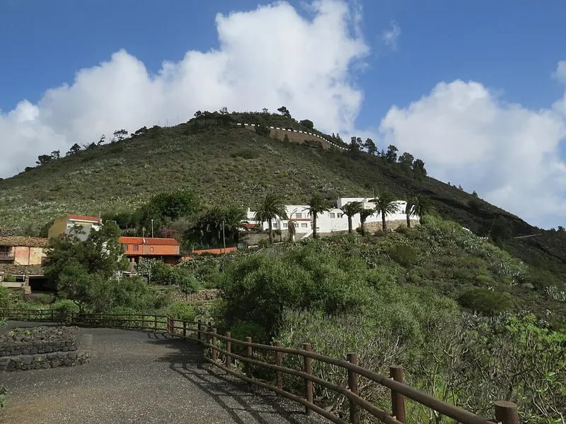
The Caserío de Bandama with white houses and palms, behind it the Pico de Bandama under clouds
The Caserío: bus stop, restaurants, start of the descent – and behind it the cone the road climbs.

Photo: Basotxerri · CC BY-SA 4.0

Side tripRoque Nublo on the same day

About an hour's drive separates Bandama from the landmark at the center of the island. Since February 3, 2025 the Cabildo has regulated access to Roque Nublo – arrive without a reservation during the day and you will be turned away.

1

Reserve in advance

Free at grancanariasenderos.com (linked from the Cabildo), QR code on your phone. At most 60 people per hour, daytime until 5 pm – the Cabildo gives 10 am as the start, press reports from the launch 9 am.

2

Shuttle instead of parking lot

The parking lot at the Degollada de La Goleta has been removed. Park in Tejeda or at the Cruz de Los Llanos, then Global line 18 every 30 minutes between 9:30 am and 6 pm. From Las Palmas lines 303/305.

3

45-minute trail

From La Goleta about 1 mile (1.5 km) to the foot of the monolith (5,948 ft / 1,813 m). Dogs on a leash. During wildfire alerts the Cabildo suspends reservations.

Sources: Cabildo de Gran Canaria (Roque Nublo access, shuttle line 18), Atlántico Hoy of February 3, 2025 (first day of the regulation).

Affiliate links to GetYourGuide: if you book, we earn a commission and the price stays the same. Prices and ratings as of 22 September 2026. On guided Roque Nublo tours the operator handles the reservation – ask before booking.

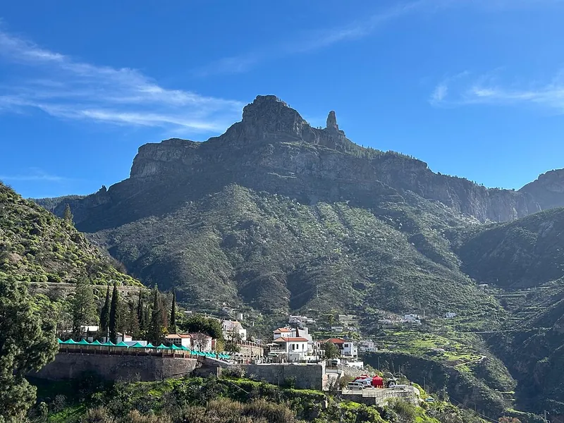
The basalt monolith Roque Nublo above the village of Tejeda in the center of Gran Canaria
Roque Nublo above Tejeda: since 2025 only with a QR code – but the code is free.

Photo: Rvr · CC BY-SA 4.0

Outdated onlineWhat other sites get wrong

“Bandama is a caldera formed by collapse.”
The name is misleading. Geologically it is a maar: magma met groundwater, and the explosions blew the funnel open (IGME, Wikipedia).
“The last eruption was 5,000 years ago.”
That is when the complex began. The youngest dated eruption was only about 2,000 years ago (IGME inventory IC3030) – the youngest on Gran Canaria.
“The descent is only possible from 8 am to 5 pm, then the gate is locked.”
Those are the times on the gate; in reality, according to Canarias7 (2022), it is no longer locked. Still, be back up before 5 pm – the Cabildo can impose closures at any time.
“Coaches drive up to the viewpoint.”
Since April 16, 2024 vehicles over 3,500 kg are banned from the road to the Pico.
“There is a visitor center with an exhibition on the Pico.”
The house at the viewpoint is a tourist information point of the Patronato; an interpretation center has been merely planned for years.

Quick answersBefore the descent

Does the Caldera de Bandama charge admission?

No. The viewpoint, the crater rim and the hike into the caldera are free; there is no ticket and no reservation. Parking at the Caserío and up on the Pico costs nothing either.

Can I hike into the Caldera de Bandama without a guide?

Yes. The Camino de Agustinito is a marked public trail. In 2024 the Cabildo renewed steps, railings and signposts – you just have to stay on the trail.

How do I get to Bandama by bus?

Global line 311 from Estación San Telmo in Las Palmas toward Santa Brígida, roughly hourly on weekdays (5:55 am–8:55 pm), about every two hours on Saturdays and holidays. The Bandama stop is at the Caserío, right at the start of the descent.

How long is the Caldera de Bandama hike?

About an hour for the descent and climb combined, 1.5–2 hours with a loop of the crater floor. The big loop including the crater rim is 4.7 miles (7.5 km) and takes about three hours.

Is the Caldera de Bandama open right now?

As of September 22, 2026 no closures are known. During wildfire warnings the Cabildo de Gran Canaria closes at short notice – current notices at cabildo.grancanaria.com.

Do I need a reservation for Roque Nublo?

Yes, during the day until 5 pm: free with a QR code via grancanariasenderos.com, at most 60 people per hour. Park in Tejeda or at the Cruz de Los Llanos, then take shuttle line 18.

How long does the descent into the caldera take?

About 170 m (560 ft) down: roughly one hour for the descent and climb combined, plus time at the old farmstead below. The 7.5 km (4.7 mile) loop including the crater rim takes about three hours.

Is the descent suitable for children?

For children who can walk for an hour on steep, slippery ground, yes. Strollers and wheelchairs are out; the viewpoint at the top, on the other hand, is accessible to everyone.

What shoes do I need?

Sturdy shoes with tread. After the paved start the trail is earth and volcanic cinder, and the climb back up in the sun is strenuous – pack water and a hat.

Can I drive to the Mirador Pico de Bandama?

Yes, the road goes up to the parking lot at 574 m (1,883 ft). Vehicles over 3,500 kg have been banned since April 2024; in the long run the Cabildo wants to close the summit road to private cars and run shuttles, but as of September 2026 that has not happened.

Is the Bandama volcano dangerous?

Volcanically, no – the last eruption was about 2,000 years ago, and the Canary traffic light for Gran Canaria is green. The hazards are rockfall on the walls, heat, and wildfire alerts with trail closures in summer.

What is the best time of day?

Mornings: the descent is still cool, the view from the Pico is usually clear, and parking is free. In the afternoon the trade-wind cloud often pushes over the center of the island.

Can I do Bandama and Roque Nublo in one day?

Yes, about an hour's drive separates them. For Roque Nublo between 9 am and 5 pm reserve in advance for free (grancanariasenderos.com) and use the shuttle from Tejeda or Cruz de Los Llanos – the old parking lot no longer exists.

Is there a restaurant or restrooms at the top?

The restrooms at the viewpoint were put back into service in 2024; at the Caserío there are restaurants and bodegas. In the crater itself there is nothing.
Sources · accessed on 22 September 2026