Volcano·Guide
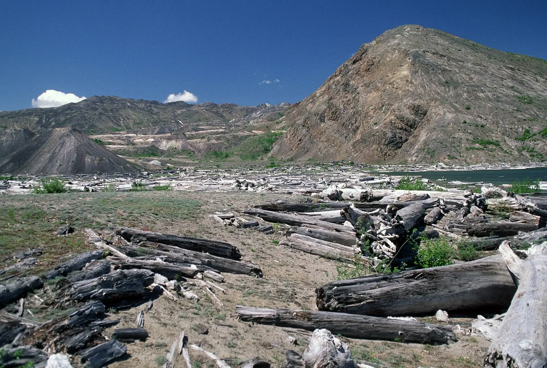
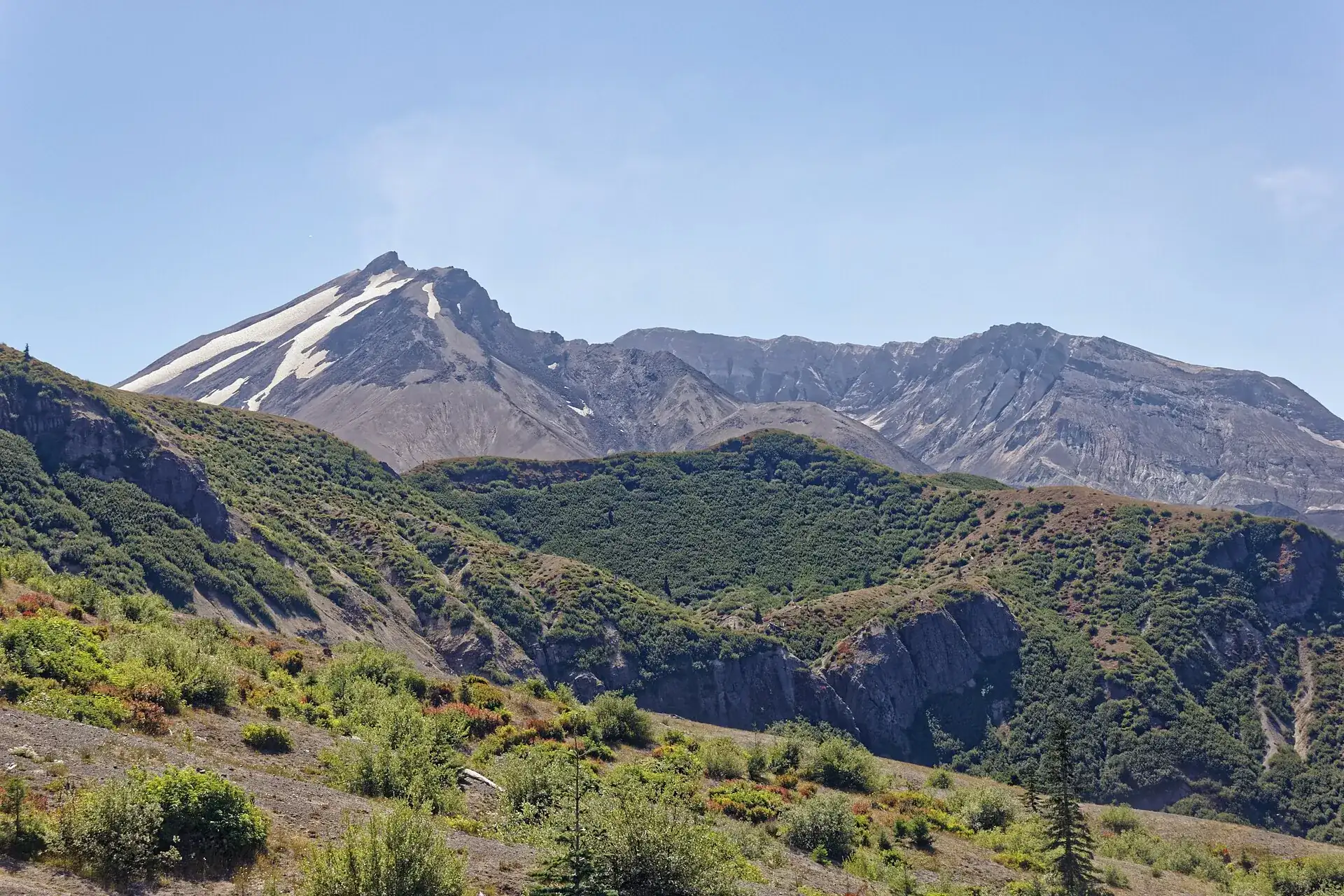
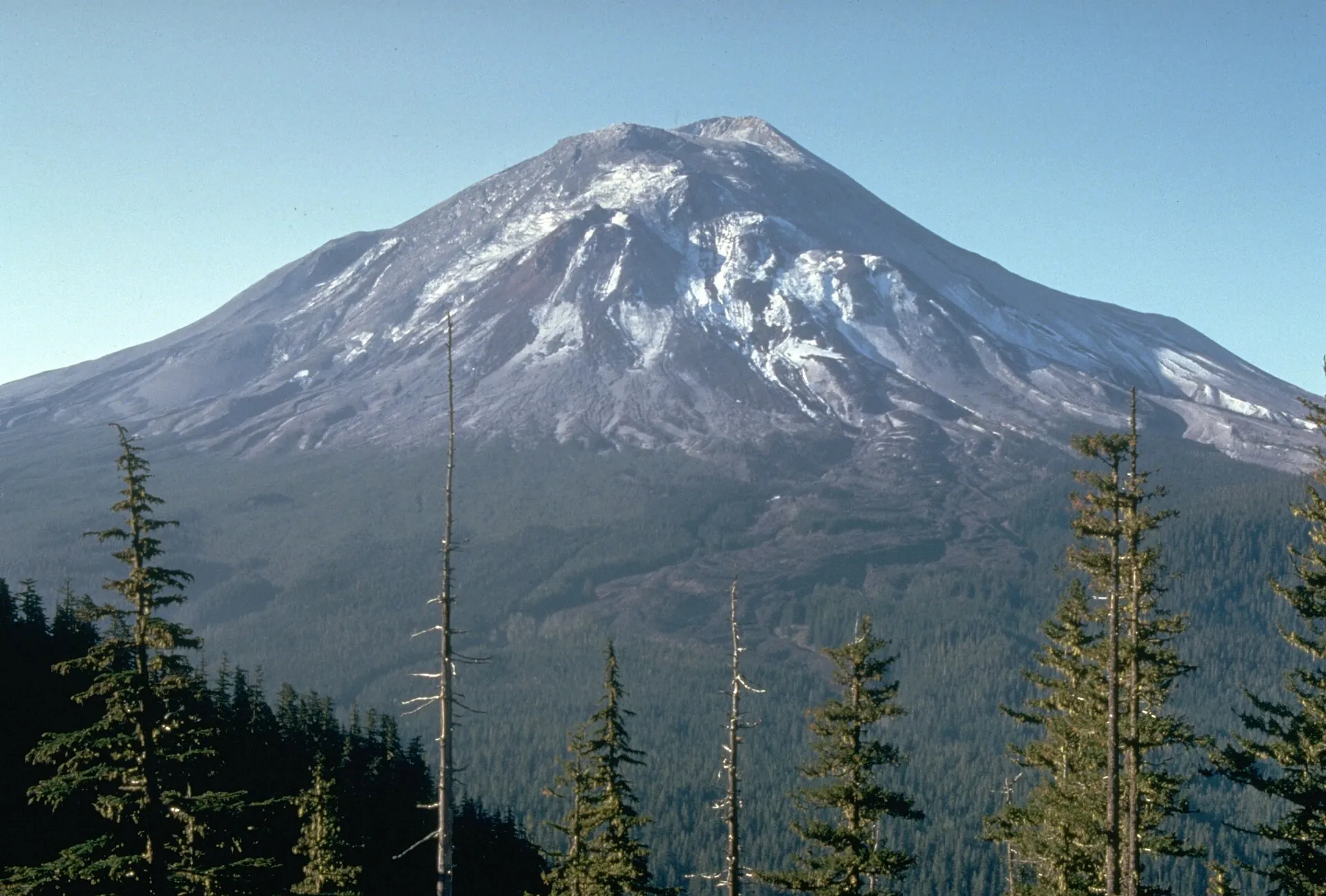
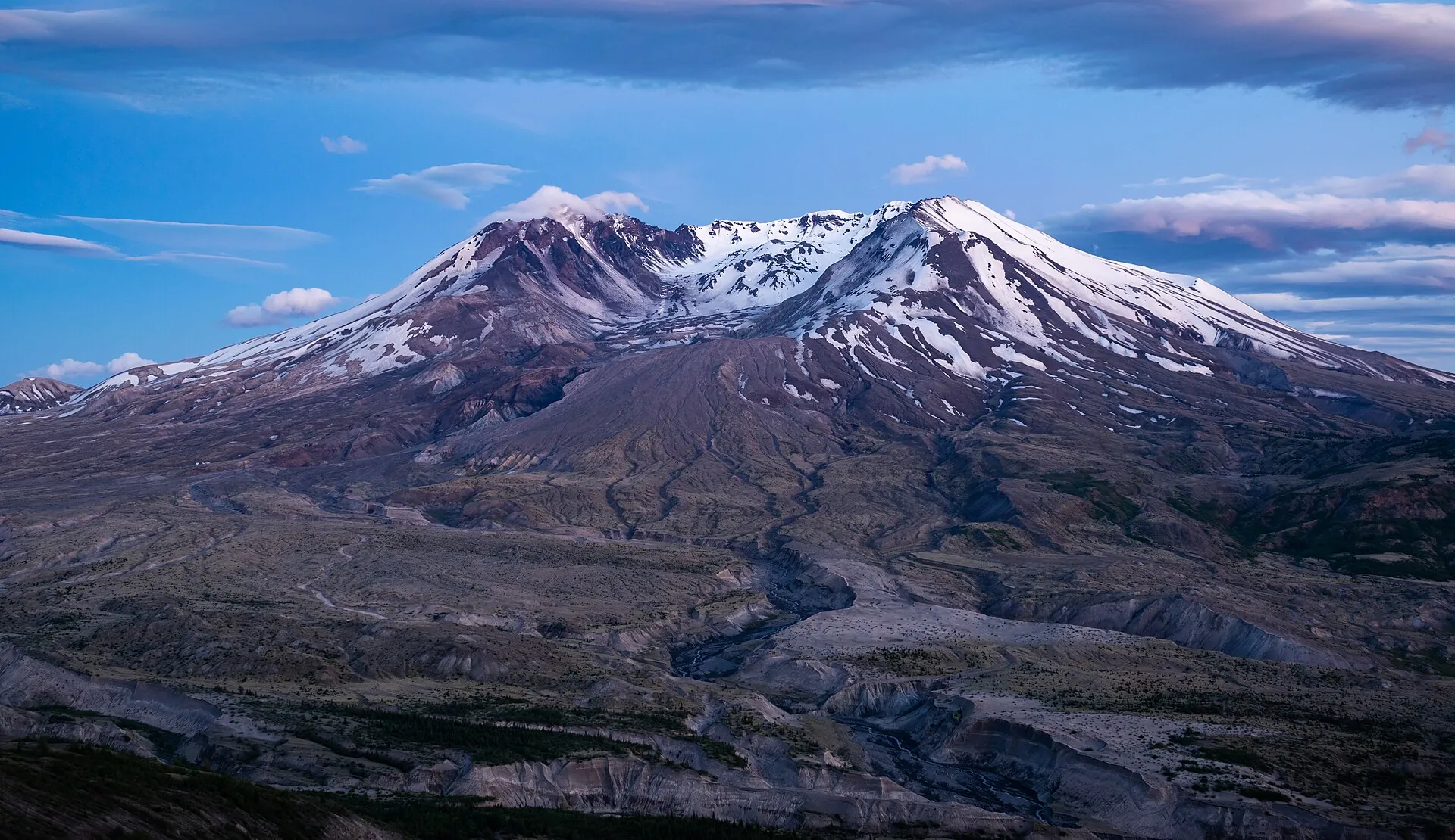
Mount St. Helens in Washington on May 17, 1980, one day before the eruption: a symmetrical, partly snow-covered cone above dark conifer forest Mount St. Helens from Johnston Ridge at dusk: the horseshoe crater open to the north above the gray pumice plain Stripped tree trunks on the shore of Spirit Lake at Mount St. Helens, with bare debris hills behind – photographed in 1999

Mount St. Helens

Until May 17, 1980, this was a symmetrical cone.

The next morning about 1,300 ft of it was gone.

Part of the flattened forest still floats on Spirit Lake.

Scroll –
the mountain loses its summit

As of 21 September 2026Mount St. Helens today: what is open and what is not

Nowhere else in the United States does volcanism look this fresh: a horseshoe crater open to the north, a pumice plain where the forest is only now coming back, a lake still full of trees felled in 1980. The planning problem is not the volcano – on September 18, 2026 the Cascades Volcano Observatory again reported NORMAL / GREEN. It is a road: since a landslide in May 2023 you can no longer drive to the famous Johnston Ridge Observatory.

Not reachable

Johnston Ridge Observatory

The Spirit Lake Memorial Highway (SR 504) is closed between mileposts 45.2 and 51 – continuously since June 10, 2024, after the South Coldwater landslide of May 14, 2023 buried the road and destroyed the Spirit Lake outlet bridge. The visitor center is closed.

Road rebuild under way since April 27, 2026, due in fall 2026
Open
43milepost

Coldwater – the substitute in the west

The Science and Learning Center at Coldwater sits at milepost 43 of SR 504, about 3,100 ft (945 m) up, and is the last viewpoint on the west side. Exhibits on the 1980 lateral blast, the short “Winds of Change” trail, Coldwater Lake. The gate stands at milepost 45.2.

day fee per vehicle · $30 for a year$5
Seasonal

Windy Ridge in the east

The closest view into the crater: about 3 miles (5 km) away, with Spirit Lake below. Access from Randle on Forest Roads 25 and 99, typically snow-free from late June to November. In 2026 trails in the FR 99 area are closed on weekdays and the restrooms are closed for rebuilding.

Fully usable on Saturdays, Sundays and federal holidays only
Permit required
20USD

The summit

Any climb to the crater rim needs a climbing permit from Recreation.gov, year-round. During the quota season from April 1 to October 31 it costs $20 per person per day, plus a $6 booking fee. Descending into the crater is prohibited.

per person per day · plus $6 per booking+$6
Sources: Forest Service closure notice for SR 504 · WSDOT on the rebuild started April 27, 2026 · CVO weekly update of September 18, 2026 · Recreation.gov – climbing permit. Accessed 21 September 2026. The Forest Service gives no reopening date for the observatory; the widely quoted year 2027 comes from reports of statements by WSDOT and the Forest Service, not from an official announcement.
The crater of Mount St. Helens seen from Windy Ridge: the open crater with a steam plume, forested ridges and gray ash slopes in front
Three miles in a straight line. You cannot get closer to this crater without climbing it.

Photo: Dirtsc · CC BY-SA 4.0

What you actually seeThe three sides of Mount St. Helens

The mountain has three sides, and they are not connected by any short road. Switching from west to east costs several hours. So you decide beforehand – and plan one day per side.

West side, from Castle Rock. An hour off I-5, about 43 miles (70 km) of highway up the valley of the Toutle River that the 1980 mudflow scoured out. At milepost 43 comes Coldwater with its exhibits, a short trail and a view over Coldwater Lake. Two miles further the gate stands. If you still want to reach Loowit Viewpoint and Johnston Ridge, the Forest Service says you can walk in from the Hummocks Trail over the Boundary Trail – a long day on foot with no services.

East side, from Randle. 19 miles on FR 25, then 16 miles on FR 99: a long, winding mountain road to Windy Ridge. From there you stand about 3 miles (5 km) from the crater, with Spirit Lake and its raft of 1980 logs below you. A stairway of 368 steps leads to the upper viewpoint.

South side, from Cougar. The side that is drivable year-round. Here you find Ape Cave – at roughly 2.5 miles (4 km) the third-longest lava tube in North America, a constant 42 °F (5.6 °C) – and Lava Canyon, a gorge the 1980 mudflow stripped bare. The summit route over Monitor Ridge also starts here.

Clear views are not a given in Washington. Before you drive, check the forecast and the Cascades Volcano Observatory webcams.

Affiliate links to GetYourGuide: if you book, we earn a commission and the price stays the same. Prices and ratings as of 21 September 2026. The choice is small: GetYourGuide lists four tours for Mount St. Helens, with twelve reviews between them. Two are new enough to have none at all. What is included is listed in each description.

The rulesWhat a visit costs – and why there is no $100 nonresident fee

Mount St. Helens is not a national park. It is a National Volcanic Monument run by the US Forest Service, and that changes the whole pricing: there is no park entrance fee, only a day fee per vehicle at certain sites – and the $100 surcharge for visitors without US residency, in force since January 1, 2026, does not apply here. It covers eleven national parks only.

Official fees · as of 09/2026
Day fee per vehicle at Windy Ridge, Coldwater, Ape Cave and other sites$5
Northwest Forest Pass, one year · covers the day fee across the Northwest$30
Climbing permit for the summit, per person per day (quota season April 1 to October 31)$20
Recreation.gov booking fee per transaction, non-refundable$6
Climbing permit outside the quota season (November 1 to March 31), self-issued at the trailheadfree
Ape Cave timed-entry reservation per vehicle, plus the day fee$2
America the Beautiful annual pass, US residents · counts as the day fee$80
America the Beautiful annual pass, non-US residents$250
The $30 Northwest Forest Pass pays off from the seventh day at fee sites – and it is valid across the Northwest. Day fees are paid on site at the machine, in cash, by check, with a valid recreation pass or digitally through the Recreation.gov app; summit and Ape Cave reservations, by contrast, are not sold on site. Sources: Forest Service – Windy Ridge, Coldwater, Ape Cave · nps.gov – Nonresident Fees (list of the eleven affected parks). Accessed 21 September 2026.

To the crater rimMount St. Helens climbing permit, step by step

The summit route over Monitor Ridge is not technical climbing, but it is a long, shadeless slog over boulder fields and deep ash – about 10 miles (16 km) round trip, roughly 4,500 ft (1,370 m) of gain, seven to twelve hours. There is no water on the way. The hard part is still the computer at home: quotas are released month by month, and summer weekends often vanish within minutes.

  1. Step 1 · beforehandCreate an account

    Permits are sold only through Recreation.gov, never on site. Set up the account and payment details in advance.

  2. Step 2 · on the 1st of the preceding month7:00 am Pacific Time

    Quotas are released month by month: on the first of the preceding month at 7:00 am PT, strictly first come, first served, with no lottery. Log in early and have your date and party size ready.

  3. Step 3 · price$20 + $6

    During the quota season from April 1 to October 31 the permit costs $20 per person per day, plus a non-refundable $6 booking fee per transaction. Maximum twelve people per group, one permit per person per day.

  4. Step 4 · if nothing is leftWatch for cancellations

    Cancellations reappear constantly. Changes to the party are possible up to seven days before the date; after that the record is fixed. Weather is not a ground for a refund.

  5. Step 5 · winterNov 1 – Mar 31 free

    Outside the quota season there are no quotas: the permit is free and self-issued at the trailhead. The route then starts at Marble Mountain Sno-Park. Winter gear and avalanche knowledge are required.

Source: Recreation.gov – Mount St. Helens climbing permit, accessed 21 September 2026. The number of permits per day is not stated there: the frequently quoted 350 places (April 1 to May 14) and 110 places (May 15 to October 31) come from secondary sources such as the Mount St. Helens Institute, as does the 4,800 ft elevation above which the permit applies. The length and elevation gain of the Monitor Ridge route are likewise widely repeated figures that do not appear in this form on the official pages we accessed. Descending into the crater is prohibited by Forest Service order – the crater rim is overhanging and unstable.

Ways to the mountainThe three sides, Ape Cave and the summit route

Four approaches, four seasons, four prices. The distances between them are the real planning factor.

Route → access, time, season, price (as of 09/2026)
West side: SR 504 to ColdwaterFrom Castle Rock, I-5 exit 49, about 43 miles (70 km) and one hour to milepost 43. The road is open to milepost 45.2 year-round; the visitor center is seasonal. $5 per vehicle per day or $30 for the year.
East side: Windy Ridge via FR 25 and FR 99From Randle, 19 miles on FR 25, then 16 miles on FR 99. A long, winding mountain road, typically open from late June to November. 368 steps to the upper viewpoint. $5 per vehicle per day. In 2026: trails in the FR 99 area closed Monday to Friday (May 15 to October 31), restrooms closed for rebuilding.
South side: Ape Cave lava tubeFrom Cougar or Woodland via SR 503 and FR 83. Lower cave 0.75 miles (1.2 km) one way and easy; upper cave 1.5 miles (2.4 km) with climbing sections plus a 1.5-mile surface return, three to four hours in total. 2026 season: May 18 to October 31, timed entry required from 9 am to 5 pm. $2 reservation per vehicle plus the $5 day fee.
Summit climb over Monitor RidgeFrom Climber's Bivouac on FR 830 on the south side. About 10 miles (16 km) round trip, roughly 4,500 ft (1,370 m) of gain, 7–12 hours over boulder fields and ash. Quota season April 1 to October 31 with a permit at $20 per person per day plus $6; from December to March, the winter route from Marble Mountain Sno-Park with a free self-issued permit.

Under the mountainApe Cave: timed entry, two lamps, 42 °F

The lava tube on the south side is the one sight at Mount St. Helens you have to book in advance – and the one where your gear actually matters.

In 2026 the cave was open from May 18 to October 31. Between 9 am and 5 pm every vehicle needs a $2 timed-entry ticket from Recreation.gov, plus the $5 day fee or a Northwest Forest Pass. One ticket covers one vehicle for one day, with a maximum of six a year, and the window is two hours long. Tickets for 2026 went on sale on April 1 at 7:00 am PT.

Two light sources per person are mandatory – the Forest Service states plainly that phone flashlights are not enough. You can rent lamps at Ape Headquarters, but only during its hours of 9 am to 5 pm. Bring warm clothes as well: the cave stays at about 42 °F (5.6 °C) all year. Do not touch the walls or ceiling, because of the bats and the microorganisms.

The lower cave works well with children. The upper cave, with its eight-foot rock step, does not.

Sources: Recreation.gov – Ape Cave timed entry and Forest Service – Ape Cave Interpretive Site, accessed 21 September 2026.
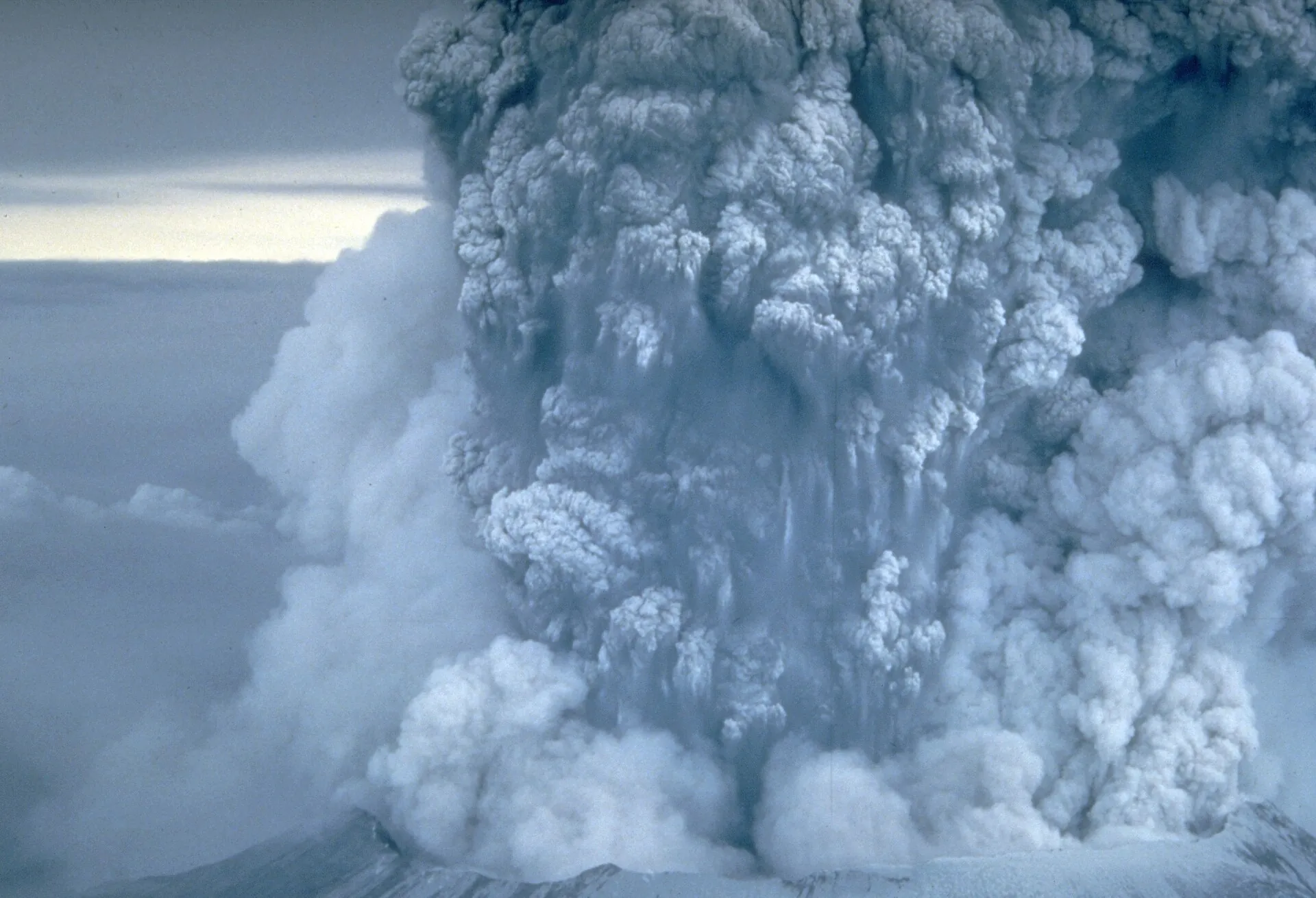
The eruption column of Mount St. Helens on May 18, 1980: a billowing gray ash cloud rising above the cloud deck
May 18, 1980, photographed by a USGS geologist. Within 15 minutes the column stood 15 miles high.

Photo: Donald A. Swanson · Public domain

The nine hoursWhat happened on May 18, 1980

Before 1980 the symmetry of Mount St. Helens earned it the name “America's Fuji.” On March 20 an earthquake swarm began, steam eruptions soon opened in the summit area, and over several weeks a visible bulge grew on the north flank.

On May 18, 1980 at 8:32 am a magnitude 5.1 earthquake triggered the collapse of the north flank – at roughly 0.6 cubic miles (2.5 km³) the largest landslide ever documented in history. The unloaded volcano exploded sideways. The blast flattened about 230 square miles (600 km²) of forest. The eruption column reached more than 15 miles (24 km) within 15 minutes, and the nine-hour Plinian eruption threw out over 540 million tons of ash, which circled the Earth in 15 days.

Fifty-seven people died, among them USGS geologist David Johnston, who was watching from a ridge 5 miles (8 km) away. Johnston Ridge is named after him – the same ridge you have not been able to drive to since 2023.

The summit lost about 1,300 ft (400 m); instead of a cone, a horseshoe crater open to the north remained. A lidar survey in 2009 measured 8,330 ft (2,539 m). In 1982 Congress designated the area around the volcano a National Volcanic Monument, explicitly so that the recolonization of the devastated ground could be watched undisturbed. From October 2004 to January 2008 a new lava dome grew inside the crater. The mountain has been quiet since, but it is not extinct: the USGS calls it the most active volcano in the Cascade range and the one in the contiguous states most likely to erupt again.

Sources: USGS – 1980 Cataclysmic Eruption · USGS – Impact (57 deaths) · USGS – Mount St. Helens (2009 lidar, dome growth, “very high” threat rating). Accessed 21 September 2026. The monument area of 172 square miles (445 km²) does not appear in that form on the Forest Service page we accessed.

Good to knowGetting there, best time to go, tips

Getting there

Without a car: There is no scheduled service. Without a car the monument is practically unreachable; commercial day tours run from Portland and Seattle.

By car: West side: I-5 exit 49 at Castle Rock, then SR 504 east to the gate at milepost 45.2. East side: from Randle via SR 131/FR 25 and FR 99 to Windy Ridge. South side: from Woodland (I-5 exit 21) via SR 503 to Cougar and on along FR 83 to Ape Cave and Climber's Bivouac. The three sides are not linked by any short road – switching from west to east costs several hours.

  • From Portland (OR) · about 1 hour to Castle Rock, about 1.5 hours to Ape Cave
    I-5 north to Castle Rock (west) or to Woodland and SR 503 (south)
  • From Seattle (WA) · about 2.5 hours to Castle Rock, about 3 hours to Coldwater
    I-5 south to Castle Rock
  • From Randle (WA) · about 1.5–2 hours to Windy Ridge
    SR 131 / FR 25, then FR 99
  • From Vancouver (WA) · about 1–1.5 hours
    I-5 north, or SR 503 to Cougar

Best time to go

July to September. Only then is the east side over FR 25/99 free of snow, Ape Cave in season and the summit route walkable without snowshoes. May and June are attractive for the summit because you can descend on firn – for that you need crampons and an ice axe. In winter the west side is open to milepost 45.2 and largely empty; the Coldwater center is then open on weekends only. A clear view of the crater is not a given in Washington: check the forecast and the CVO webcams before you drive.

Who it suits

Children
Coldwater, Windy Ridge and the lower Ape Cave work well with children. The upper Ape Cave, with its eight-foot rock step, and the summit climb do not.
Minimum age
no formal minimum age; the summit route is a full-day, shadeless climb
Fitness
Summit: about 4,500 ft (1,370 m) of gain over boulder fields and deep ash, 7–12 hours. Very strenuous, but technically not climbing.
Wheelchair
Coldwater and the “Winds of Change” trail are built up; Windy Ridge has a 368-step stairway to the upper viewpoint, while the lower area is level.
Dogs
Leashed dogs (leash no longer than 6 ft / 1.8 m) are allowed on designated trails, but not inside the Coldwater building. In parts of the monument, pets other than service animals are prohibited.
Clothing
On the summit route, wind and sun protection and plenty of water (there is none on the way). Ape Cave stays at about 42 °F (5.6 °C) year-round – take a jacket and a hat even in August.
Footwear
Summit and Ape Cave: sturdy, ankle-high shoes with a good tread; gaiters against ash are very welcome on the descent.

Tips you will need on site

  • Take Johnston Ridge off your plan and choose instead: Coldwater (west, easy to reach but 10 miles from the crater) or Windy Ridge (east, close to the crater but a two-and-a-half-hour detour).
  • Pick a Saturday or Sunday for Windy Ridge: trails and areas along FR 99 are closed on weekdays from May to October.
  • Book summit permits on the first of the preceding month at 7:00 am PT. Log in beforehand and have your date and party size ready.
  • If you only have one weekend and no permit: cancellations reappear constantly, and changes to the party are possible up to seven days before – after that the record is fixed.
  • Ape Cave: bring two proper lamps per person. You can rent lamps at Ape Headquarters, but only during its hours of 9 am to 5 pm.
  • The $30 Northwest Forest Pass pays off from the seventh day at fee sites – and it is valid across the Northwest.
  • Mount St. Helens is not run by the National Park Service. The $100 nonresident fee does not apply here.
  • There is no water and no shade on the summit route. Plan on three to four liters per person and start early.

A short history

  • Before 1980, the symmetry of Mount St. Helens earned it the name “America's Fuji”; according to the USGS it is the most active volcano in the Cascade range.
  • On March 20, 1980 an earthquake swarm began, steam eruptions soon opened in the summit area, and over several weeks a visible bulge grew on the north flank.
  • On May 18, 1980 at 8:32 am a magnitude 5.1 earthquake triggered the collapse of the north flank – at roughly 0.6 cubic miles (2.5 km³) the largest landslide documented in history.
  • The unloaded volcano exploded sideways: the blast devastated about 230 square miles (600 km²) of forest, the eruption column reached more than 15 miles (24 km) within 15 minutes, and the nine-hour Plinian eruption threw out over 540 million tons of ash, which circled the Earth in 15 days.
  • Fifty-seven people died, among them USGS geologist David Johnston, who watched the eruption from a ridge 5 miles (8 km) away – Johnston Ridge is named after him.
  • The summit lost about 1,300 ft (400 m); instead of a cone, a horseshoe crater open to the north remained. A lidar survey in 2009 measured 8,330 ft (2,539 m).
  • In 1982 Congress designated 172 square miles (445 km²) around the volcano as Mount St. Helens National Volcanic Monument – explicitly so that the recolonization of the devastated ground could be observed undisturbed.
  • From October 2004 to January 2008 a new lava dome grew inside the crater; the volcano has been quiet since, but it is not extinct.
  • On May 14, 2023 the South Coldwater landslide buried the Spirit Lake Memorial Highway and swept away the Spirit Lake outlet bridge – Johnston Ridge has been cut off from cars ever since.

Outdated onlineWhat other sites get wrong

“Johnston Ridge Observatory is open.”
SR 504 has been closed between mileposts 45.2 and 51 since the landslide of May 14, 2023, and the observatory is shut. WSDOT has been rebuilding since April 27, 2026, with completion due in fall 2026; the Forest Service expects to reopen the observatory after that.
“You just drive up the road from Castle Rock to the crater.”
Since 2023 the drive ends at the Hummocks Trailhead, about 10 miles (16 km) short of Johnston Ridge. To see the crater head-on you have to go around to the east side – or walk a long way.
“Mount St. Helens is a national park.”
It is a National Volcanic Monument of the Forest Service. Neither the national park entrance fee nor the $100 nonresident fee applies here; the day fee and the Northwest Forest Pass do.
“The climbing permit costs $15.”
Out of date. Recreation.gov lists $20 per person per day for the quota season, plus a $6 booking fee per transaction.
“For Ape Cave you just show up.”
In season there is a timed-entry requirement. In 2026 the cave was open from May 18 to October 31; between 9 am and 5 pm every vehicle needs a $2 ticket from Recreation.gov, plus the day fee.
“The mountain is 9,677 ft high.”
It was, before 1980. The eruption took about 1,300 ft off it; a lidar survey in 2009 measured 8,330 ft (2,539 m).
“You can hike down into the crater.”
That is expressly prohibited. The monument order penalizes entering the crater with fines of up to $5,000, up to six months in jail, or both.

Quick answersBefore you drive to Mount St. Helens

Can you visit Mount St. Helens in 2026 at all?

Yes. Only the upper section of the west side, with Johnston Ridge Observatory, is closed. Coldwater at milepost 43 in the west, Windy Ridge in the east and the entire south side with Ape Cave and Lava Canyon are open.

Is Mount St. Helens worth it without Johnston Ridge?

For a view into the crater, yes – but from the east. Windy Ridge sits about 3 miles (5 km) from the crater and adds Spirit Lake. The west side is easier to reach and has the exhibits on the lateral blast at Coldwater.

How long is the drive from Seattle or Portland?

From Portland about an hour to Castle Rock on the west side and roughly an hour and a half to Ape Cave in the south. From Seattle it is about two and a half hours to Castle Rock. Windy Ridge in the east is another one and a half to two hours beyond Randle.

Can you combine the west and east sides in one day?

Not realistically. The sides are not directly connected, and going around costs several hours. Better: one day on the west side with Coldwater, one day on the east side with Windy Ridge, or the south side with Ape Cave and Lava Canyon.

When is the best time to visit Mount St. Helens?

July through September. Only then is the east side over FR 25 and 99 free of snow, Ape Cave in season and the summit route walkable without snowshoes. May and June are attractive for the summit because you can descend on firn – but that calls for crampons and an ice axe.

Do you need a guide?

No. Neither the summit climb nor Ape Cave requires one. Guided climbs are offered by the Mount St. Helens Institute among others, but they are voluntary.

Is Johnston Ridge Observatory open in 2026?

No. The Spirit Lake Memorial Highway has been closed between mileposts 45.2 and 51 since the landslide of May 14, 2023, and the observatory is shut and unreachable by car. The road rebuild has been under way since April 27, 2026 and is due to finish in fall 2026; reopening the visitor center is expected in 2027.

Where is the best place to see the Mount St. Helens crater now?

From Windy Ridge on the east side: about 3 miles (5 km) from the crater, with a view over Spirit Lake. The drive goes from Randle over Forest Roads 25 and 99 and is free of snow only from about late June to November. On the west side, Coldwater at milepost 43 is the last point with a view.

What does it cost to visit Mount St. Helens?

There is no park entrance fee, only a $5 day fee per vehicle at sites such as Windy Ridge, Coldwater and Ape Cave. A $30 Northwest Forest Pass or an interagency pass covers it. The summit climb costs extra.

Do visitors from outside the US have to pay the $100 fee?

No. The $100 surcharge for visitors without US residency, in force since January 1, 2026, applies only at eleven national parks – Mount St. Helens is a National Volcanic Monument of the Forest Service and not among them.

How do I get a permit for the climb?

Only through recreation.gov. Quotas are released month by month: on the first of the preceding month at 7:00 am Pacific Time, first come, first served, with no lottery. During the season from April 1 to October 31 the permit costs $20 per person per day plus a $6 booking fee.

Can you climb Mount St. Helens in winter?

Yes. From November 1 to March 31 there are no quotas; the permit is free and self-issued at the trailhead. The route then starts at Marble Mountain Sno-Park, and your car needs a Washington Sno-Park permit. Winter gear and avalanche knowledge are prerequisites.

How hard is the climb up Mount St. Helens?

Technically easy, physically hard: about 10 miles (16 km) round trip, roughly 4,500 ft (1,370 m) of gain over boulder fields and deep ash, seven to twelve hours. There is no water and no shade on the way. No climbing skills are needed.

Are you allowed into the crater?

No, it is prohibited by Forest Service order. Violations can be punished with fines of up to $5,000, up to six months in jail, or both.

What do I need to take into Ape Cave?

Two proper light sources per person – the Forest Service states explicitly that phone flashlights are not enough. Add warm clothing, because the cave stays at about 42 °F (5.6 °C) year-round, and sturdy shoes. Do not touch the walls or ceiling.

Is Mount St. Helens dangerous right now?

No. On September 18, 2026 the Cascades Volcano Observatory again reported NORMAL/GREEN for all Cascade volcanoes. The volcano is nonetheless considered the most active in the Cascades and the one in the contiguous states most likely to erupt again.

How long does it take from Portland or Seattle?

From Portland about an hour to Castle Rock on the west side and roughly an hour and a half to Ape Cave in the south. From Seattle it is about two and a half hours to Castle Rock. Windy Ridge on the east side is another one and a half to two hours beyond Randle.

Are dogs allowed?

On a leash on designated trails, yes; inside the Coldwater building, no. In parts of the monument, pets other than service animals are prohibited entirely – check the current Forest Service order before you visit.
Sources · accessed on 21 September 2026